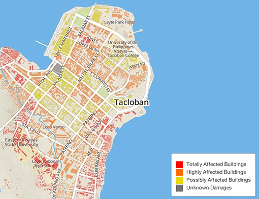
Mapping impact on houses in Tacloban
In the aftermath of a disaster, lack of information about the affected areas can hamper relief and recovery efforts. Open-source mapping tools provide a much-needed low-cost high-tech opportunity to bridge this gap and provide localized information that can be freely used and further developed.
A week ago, devastating typhoon Haiyan hit the Philippines. As the images of the horrifying destruction emerge, there is a clear need in accessing localized high-resolution information that can guide communities’ recovery and reconstruction. Responding to this challenge, over 766 volunteers have been activated by the Humanitarian OpenStreetMap Team (HOT) to create baseline geographic data which can be freely used by the Philippine government, donors and partner organizations to support all phases of disaster recovery.
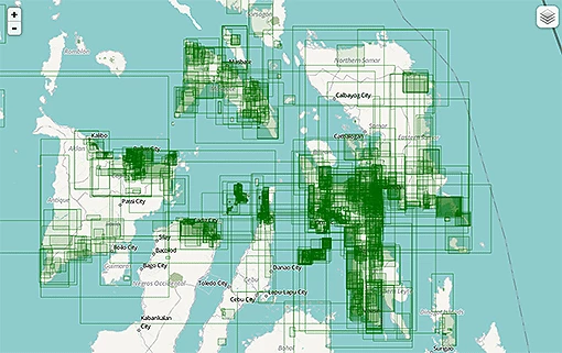
OpenStreetMap (OSM) is a global initiative relying on volunteers to create a global “wikimap” with detailed information. Since 7th November, working square by square adding information on the map of the typhoon-affected areas, this online community has made over 1.7 million edits to the map, digitizing tens of thousands of individual buildings, identifying land-use and roads and damaged structures. The picture below shows the work in progress.
Work in progress – digitizing images for the Philippines through OpenStreetMap
Unlike many proprietary images, data collected and shared by the OSM community is freely available and can be exported by users in various formats and different purposes. For example it can be used for ongoing assessments of the damages and scope of the disaster or guide actions in the next phases of the recovery and reconstruction process. The American Red Cross has already used these maps, which didn’t exist until a few days ago, to help guide response efforts.
While the work has only started, early results and the particularly active engagement of the Philippines-based OSM mappers show tremendous potential of this initiative. Hosted by the University of the Philippines Geography Department, there are a number of “mapathon” events planned in the coming days in Manila to expand the volunteer efforts that anyone with basic IT skills can join. Volunteers in DC can also contribute by joining @OpenStreetMap at @CrisisCamp on Saturday 16 November 2013.
OSM volunteers have made a crucial contribution to the relief and recovery efforts after the 2010 Haiti earthquake, providing detailed information that helped guide search and rescue teams, locate emergency shelters and plan resettlement activities. In Indonesia, participatory mapping in Jakarta has created detailed neighborhood maps with administrative boundaries, disaster response assets such as shelters, logistic centers and evacuation routes for flood preparedness, as well as information about flood-exposed communities and structures that can be used by local authorities for contingency planning and disaster preparedness.
Over the past years, the World Bank/Global Facility for Disaster Reduction and Recovery (GFDRR) has supported participatory mapping in Haiti, Indonesia, the Philippines, Colombia, Nepal, Sri Lanka and Bangladesh (see Open Data for Resilience Initiative). Through our engagement, we have already seen the great value that the OSM community can offer to the communities at risk from natural hazards.

Join the Conversation