Also available in: Español
John Grunsfeld, former NASA Chief Scientist and veteran of five Space Shuttle flights, had several chances to look down at Earth, and noticed how poverty can be recognized from far away. Unlike richer countries, typically lined in green, poorer countries with less access to water are a shocking brown color. During the night, wealthier countries light up the sky whereas nations with less widespread electricity look dim.
Dr. Grunsfeld’s observation might have important implications. Pictures from satellites could become a tool to help identifying where poverty is, by zooming in to the tiniest villages and allowing a constant monitoring that cannot be achieved with traditional surveys.
“The accuracy of global poverty numbers depends on the availability of household surveys,” writes Chandy (2013) and “this remains one of the biggest constraints to poverty data today.” Two fifths of countries fail to conduct a household survey every five years. Even when household surveys are conducted, the poor tend to be hard-to-reach by survey or census takers and data quality is generally low. On the contrary, satellites gather data at a constant rate throughout the year, regardless of physical or social hazards.
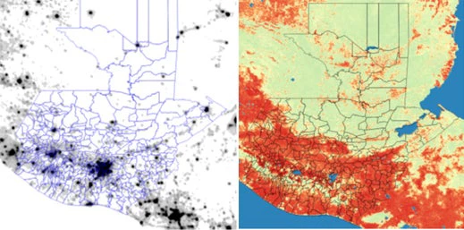
In a recent paper (Klemens, Coppola and Shron 2015), we used Guatemala as a case study to test the potential of satellite data by combining night luminosity data and data on foliage extracted from satellite pictures with the information provided by the survey data traditionally used to measure poverty. Guatemala is an interesting case because the Guatemalan Instituto Nacional de Estadıstica (INE) provides data on urban and rural poverty separately, so we were able to do some exercises distinguishing between urban and rural municipalities. In particular, we analyzed the relationship between existing urban and rural small-scale poverty estimation (based on census and household survey information), nighttime illumination (from the U.S. National Oceanographic and Atmospheric Administration, NOAA), reflectivity of the earth's surface (from the U.S. National Aeronautics and Space Administration, NASA), and leaf coverage (also from NASA).
Can a picture from space help to measure poverty in a Guatemalan village? Our findings indicate that satellite imaging data can add valuable information to improve poverty measurements. For ordinary least squares regressions with poverty measures as a dependent variable, the corrected Akaike information criterion (or AICc, a measure of the relative quality of statistical models) improves when luminosity measures are included. We also found that the same type of satellite information can be more or less significant for different type of studies. For instance, in our regressions regarding rural poverty, luminosity data was significant; however, in our regressions regarding urban poverty, luminosity data was not. Satellite measures of foliage showed less correlation to poverty measures than luminosity.
At this stage, satellite data can’t replace traditional survey data to measure poverty. However, it may certainly add value and improve estimation results. We should keep exploring the opportunities of using new technology and innovative data sources to help us to address development challenges.


Join the Conversation