Improving the Impact of Development Assistance Starts With Geography
Where are World Bank projects located and are they making a tangible difference in the lives of developing country communities?
An expanded version of the Mapping for Results (M4R) platform was launched during the 2011 World Bank-IMF Annual Meetings to better enable donors, governments and citizens in answering these pressing questions.
Figure 1: World Bank financed activities in Nepal with poverty map.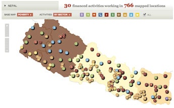
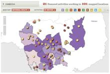
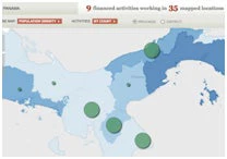
Overlaying indicators on poverty, education and health with geographic locations of World Bank financed projects, the M4R platform helps policy makers and civil society groups visualize the distribution of projects, identify beneficiaries and monitor results on development outcomes. Building upon the initial foundation laid in October 2010, the new M4R platform expands the number of countries mapped from 79 to 144, including more than 30,000 locations related to active World Bank-financed projects.
For select countries, the M4R platform provides not only geographic information of World Bank financed programs at the sub-national level, but also allows users to overlay disaggregated poverty, population density, and human development data. More specifically, sub-national data is available on population density for 107 countries, human development data such as infant mortality, maternal health, and malnutrition for 43 countries, and poverty data for 31 countries.
Seeing the importance of sustaining this open flow of information to democratize development, the World Bank is institutionalizing mapping of project locations as part of its ongoing project planning and reporting cycle. As of July 2011, World Bank operational teams are collecting location information for all investment-lending projects.
For more information on the World Bank’s Mapping for Results platform, visit: http://maps.worldbank.org/about.

Join the Conversation