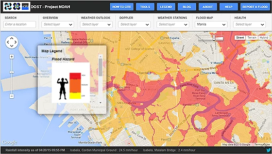
World Champion boxer Manny Pacquiao is a living icon in the Philippines, his legendary battles are well known and brought him considerable fame. This fame and recognition is being used by the Philippine government (through Project NOAH) to save lives and minimize losses from disasters—where an infographic gradient links flood depth to Pacquiao’s famous height. In other words, to encourage adoption of early warning advisories and make flood hazard projections more interesting, yellow colors on interactive flood hazard maps equate to flood levels up to Pacquiao’s knees, while a dangerous, bright red color corresponds to high flood levels that are taller than Pacquiao himself.
This memorable anecdote aptly encompasses the level of enthusiasm, energy and creativity of disaster practitioners and technical agencies in pioneering countries who are increasingly using innovative tools and ‘catchy’ community-driven approaches to tackle disaster risks. At the World Conference for Disaster Risk Reduction (WCDRR) in Sendai, we met disaster practitioners from Indonesia and the Philippines who are embracing innovative approaches to positively affect the lives of at-risk communities prior to disasters.
But how are technological tools driving this new approach?
mapping in the Philippines to strengthen
disaster preparedness
Image: World Bank/GFDRR
The Indonesian national disaster risk management agency—BNPB—organized an illuminating symposium at the WCDRR which showcased a number of user-friendly tools, which, when used together, provide a comprehensive awareness, preparedness and response information system, such as:
- InaTEWS (Indonesia Tsunami Early Warning System) which relays earthquakes and tsunami signals within five minutes of an event and quickly disseminates early warning alerts through a wide range of communication channels (GSM network, institutional interface, electronic media, etc.)
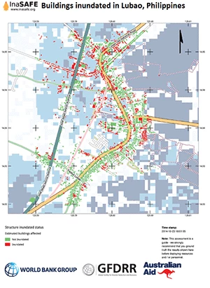
- InaSAFE (Indonesia Scenario Assessment for Emergencies) is a user-friendly visualization and rapid analysis tool which uses impact scenarios to support local officials and disaster practitioners by providing emergency advice and local infrastructure recommendations.
- InAWARE (Indonesia All-hazards Warning and Risk Evaluation) improves early warning capacity and decision-making outcomes with improved access to external information sources and by providing information that rapidly shared with at-risk communities in targeted areas.
Also showcased was the Philippine Department of Science and Technology’s Project NOAH which is also at the forefront of this disaster information revolution, shifting the way risk data is collected, visualized and disseminated as actionable information. Dr. Mahar Lagmay, Project NOAH’s Executive Director, is a fervent advocate of the use of open-source tools and open data to support disaster preparedness. “Disaster risk management will never be comprehensive and up-to-date if stakeholders are selfish and do not share risk data”, he explained at the WCDRR, “…on the other hand, open source software can accelerate disaster preparedness, minimize vulnerability of communities, and in the long term ensures that natural hazards do not turn into catastrophic disasters due to poor planning.”
Finally, in tackling data deficits, the positively disruptive power of OpenStreetMap was highlighted by all the contributors—in countries where data just doesn’t exist, engaging the power of the crowd (including at-risk communities) to generate or crosscheck much needed risk data is a tremendous opportunity—and one being grabbed with the power of a World Champion boxer!
These, and many other insightful tools have in the past years revolutionized the way rigorous science and creative partnerships can leverage local knowledge to strengthen resilience at a local level. We also welcome the recent launch of a Challenge Fund (in partnership with the UK Department of International Development) to further drive user-centered innovation in Disaster Risk Identification.
For more information how the World Bank and the Global Facility for Disaster Reduction and Recovery (GFDRR) works with partners to support innovative open-source technologies and community risk mapping initiatives, click here


Join the Conversation