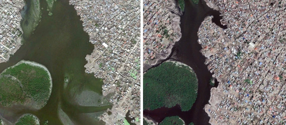
 and 2021 (right)") River-side settlement expansion in Quảng Nam, Vietnam, 2002 (left) and 2021 (right)
River-side settlement expansion in Quảng Nam, Vietnam, 2002 (left) and 2021 (right)
The world’s cities are growing rapidly as people move in search of economic opportunities. Urbanization and economic development have traditionally gone hand in hand as cities attract people, ideas, and capital, and foster agglomeration economies. However, rapid urbanization can also cause congestion effects; for instance, by increasing exposure to natural hazards and pressure on public services and infrastructure.
The effect of rapid urbanization on flood risks and people’s vulnerability is an intensifying challenge for low and middle-income countries. This is particularly relevant in countries that lack the capacity for risk-informed urban and infrastructure planning and the resources to invest in protection infrastructure. And as safe spaces for construction are increasingly occupied, high population density and land scarcity are driving new developments disproportionately into previously avoided areas, including riverbeds and flood plains.
In a study just published in the journal Nature, and financially supported by the Global Facility for Disaster Reduction and Recovery (GFDRR), we provide systematic evidence that communities around the world – from rural villages to large cities – have been continuously and rapidly expanding into flood zones. Despite the evidence that climate change will make extreme precipitation and floods more frequent in many regions, many countries continue to increase their exposure to such threats with unplanned urban expansion.
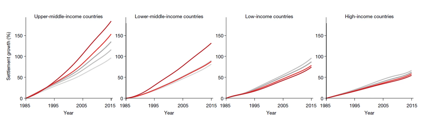
Most rapid high-risk growth in East Asia, and upper-middle-income countries
In many regions, growth in the most hazardous flood zones has been outpacing growth in safe zones by a large margin. This is particularly true in East Asia, where high-hazard settlements have expanded 60% faster than flood-safe ones. More generally, this is true in middle-income countries (MIC), where economies and cities have grown rapidly over the past decades. The effects are most visible in upper-middle-income countries, which have a higher proportion of settlements in the highest-hazard areas than any other group. Since 1985, these have grown by 184% —nearly twice the rate of flood-safe settlements (96%). These expanding settlements in high-hazard areas lock in flood exposure, as well as future losses and the need for ever-mounting flood protection investments.
Settlement growth (%) by hazard level
Slow and safe urban growth in low-income countries so far
Compared with MICs, low-income countries (LIC) have seen moderate settlement growth since 1985, and this growth is mostly occurring on safe land: on average, settlements in high-hazard areas have grown 77%, compared to 87% in safe areas. The slower urbanization in these countries is likely to create less pressure to use all available land, including the riskiest one.
These trends are likely to change in the future. As today’s LICs follow on a path of economic growth, urbanization rates are likely to accelerate, which is conducive to faster development. But without risk-informed urban planning and appropriate zoning policies, climatic risk exposure in low-income urban hubs is likely to increase in the future.
What it means for urban planning and climate resilience
It can be politically convenient to see climate change as an exogenous force that places disasters beyond the influence of local authorities. However, locally determined patterns of urbanization and spatial development are key factors in people’s exposure and vulnerability to climatic shocks.
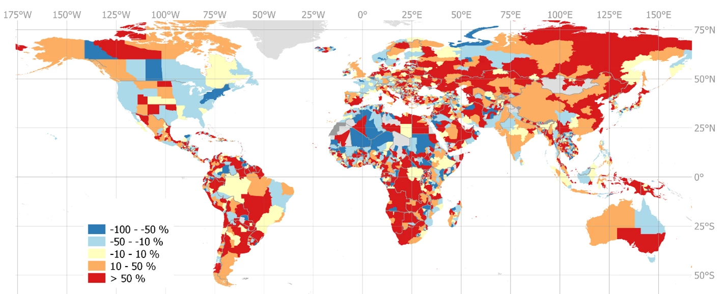
Subnationally disaggregated results show a pattern of divergence in exposure to flood hazard, with flood-safe growth dominating in some locations, while others are increasing their relative exposure to floods. This highlights a key responsibility that falls on municipalities and subnational governments, who often are charged with land-use and urbanization plans and regulations (including their enforcement).
Flood-safe vs flood-exposed growth: Relative difference between settlement growth in safe and high hazard areas 1985 to 2015
In an age of increasing disaster losses due to flood events, effective flood risk mitigation efforts must be based on a robust understanding of the different contributing factors to flood risk. These can include intensifying hazards (e.g., due to climate change), increasing exposure to hazards (due to expanding at-risk settlements), and rising vulnerability to shocks (e.g., due to inadequate building standards or social protection systems). Using data with high spatiotemporal resolution, our study shows that rising exposure is key to understanding the global rise in flood disaster losses – continuous monitoring of urbanization and flood exposure patterns can help guide timely interventions.
These findings have concrete implications for urban planners and policy makers. In areas where flood exposure is already high, investments in disaster preparedness and protection are crucial to mitigate losses (e.g. early warning systems, social protection, and protective infrastructure). In areas where flood exposure is still low but rapidly increasing, revision of land use and urbanization plans are urgent priorities to avoid new construction in the highest-risk areas : once an area is urbanized, it is impossible or prohibitively expensive to reverse it, thus locking-in high-risk patterns with large economic and human consequences. While land scarcity and geographic constraints can mean that flood zones cannot always be avoided, careful planning of protection systems and disaster preparedness can support resilient development.
Related:


Join the Conversation