Technological progress, however, is quickly creating new ways for governments and development agencies to overcome data scarcity. In Belize, the World Bank has partnered with the government to develop an innovative approach and inform climate-resilient road investments through the combination of creativity, on-the-ground experience, and strategic data collection.
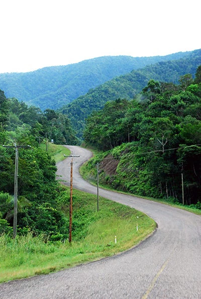
Underdeveloped infrastructure, particularly in the transport sector, is a key constraint to disaster risk mitigation and economic growth in Belize. The road network is particularly vulnerable due to the lack of redundancy and exposure to natural hazards (mostly flooding). In the absence of alternative routes, any weather-related road closure can cut access and severely disrupt economic and social movement.
In 2012, the government made climate resilience one of their key policy priorities, and enlisted the World Bank’s help in developing a program to reduce climate vulnerability, with a specific focus on the road network. The institution answered the call and assembled a team of experts that brought a wide range of expertise, along with experience from other climate resilience interventions throughout the Caribbean. The program was supported by Africa, Caribbean and Pacific (ACP) European Union funds, managed by the Global Facility for Disaster Reduction and Recovery (GFDRR).
Our strategy to address data scarcity in Belize involves three successive, closely related steps.
Step 1: Build a solid decision-making framework to identify priority road investments
The team started off by coordinating the development of a decision-making framework that would help prioritize investment based on two complementary factors:
- Criticality: from a social and economic standpoint, which roads are most important to the country? To answer this question, we relied on a participatory Multi Criteria Evaluation (MCE) process that allowed us to identify road stretches critical for access to public services such as hospitals and schools, movement of economic products and services, and use in evacuation routes as well as those that provide access to the socially vulnerable. Representatives from over 35 ministries, municipalities, private sector organizations, civil society, nongovernmental organizations (NGOs), and academic institutions took part in the establishment of these criteria. Once these were defined, the participants developed indicators to evaluate the criteria and scored each indicator, which enabled a thorough quantitative analysis of the road network.
- Vulnerability: how would different stretches of the road network be affected by weather events, especially flooding? To overcome the scarcity of data on flood susceptibility, the team carried out a detailed survey of the entire primary and secondary road network, combined with an extensive analysis of existing data. This work culminated in the creation of a geospatial model to assess the vulnerability of roads across the country.
Step 2: Share lessons learned with other transport practitioners
Based on this experience, our team authored a Practitioner’s Guide to Prioritize Climate-Resilient Transport Investments in a Data-scarce Environment . For transport professionals working in areas with limited data availability, this publication provides a new set of tools to make more informed decisions about transport planning, asset management, and investment. It was designed to benefit a broad and diverse audience, including government officials, transport specialists, decision makers, climate change and disaster risk management specialists, as well as private developers . Although it is based on our engagement in Belize, the guide proposes an approach that can be replicated and adapted to other contexts.
Step 3: Make your data accessible through a user-friendly interface
In order to get the most out of our work, the government needed a user-friendly system to access and use the data collected through the road survey. Our team is now working on a Transport Asset Management Technical Assistance program, which will ultimately lead to the development of a computational platform to allow easy data visualization, queries, and simple analysis. In that context, we are collaborating with the Ministry of Works on a new road asset management system that will enable the government to quickly access, update, and manage the rich database developed through this engagement.
Together, these tools will significantly enhance the government’s capacity to better plan, build and maintain its critical road transport assets in light of known disaster and climate risks.
After overcoming data scarcity with an innovative approach, the government is now implementing a World Bank-funded Climate Resilient Infrastructure Project for $30 million. Belize has also been able to use the results from the prioritization process described above to leverage funding from bilateral and other multilateral donors and support climate resilience projects across the road network.


Join the Conversation