In a 2013 interview, UNOSAT Manager Dr. Einar Bjorgo described the work of his office.
“When a disaster strikes, the humanitarian community typically calls on UNOSAT to provide analysis of satellite imagery over the affected area… to have an updated global view of the situation on the ground. How many buildings have been destroyed after an earthquake and what access roads are available for providing emergency relief to the affected population? We get these answers by requiring the satellites to take new pictures and comparing them to pre-disaster imagery held in the archives to assess the situation objectively and efficiently.”
Four years later, UNOSAT’s work seems to have become even more important and has evolved from the early days when the group used mostly freely available imagery and only did maps.
“Since [2001] we have evolved into a wide variety of applications, both in terms of internal satellite analysis, but also capacity development,” said Bjorgo via email. “This includes…refugee camps and internally displaced persons mapping, damage assessments in conflicts… disaster risk reduction and more.”
Like other mapping programs, UNOSAT engages multiple tools to provide an analysis of a humanitarian event – sometimes even before the event happens.
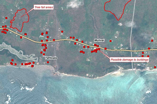
“[For example, when] Hurricane Matthew was forecasted to hit Haiti in October 2016, we were requested by [UNOCHA] to activate our Rapid Mapping Service and provide satellite imagery based analysis to support the humanitarian emergency response,” said Bjorgo. “We first provided population exposure analysis… before the hurricane hit.”
After the hurricane passed, UNOSAT analyzed post-event satellite imagery for damage to infrastructure and provided maps, GIS ready-to-use data, reports and statistics to the humanitarian community.
It’s easy to see why many find these offerings so valuable; UNOSAT’s use of full-color imagery accompanied by detailed analyses of events and their impacts are concise and easily understood. For a humanitarian responder, this relative ease of presentation would be a life-saver, enabling a more efficient response.
What’s next?
Like others in this ever-evolving field, Bjorgo sees limitless opportunities for growth, due in large part to the rapid pace of technological development. UNOSAT continues to expand the use of geo-spatial technologies and is also exploring virtual and augmented reality.
Virtual and augmented reality use aerial photos and video to create 3-D computer models of humanitarian events which are then used to allocate humanitarian resources. Aerial robotics, aka drones, are another crisis mapping resource and are used to photograph, assess and document crisis events. Drones are becoming increasingly important due to their ability to go where workers can’t.
HOT is researching the use of AI to extract structures from satellite imagery, and Artificial Intelligence for Disaster Response ( AIDR) – another platform developed by the prolific Patrick Meier and his colleagues at the Qatar Computing Research Institute (QCRI) – utilizes AI to “filter and classify social media messages related to emergencies… [using] human and machine intelligence to automatically tag up to thousands of messages per minute.”
Adding to this diverse mix, the United Nations Committee of Experts on Global Geospatial Information Management (UN-GGIM) has identified the adoption and use of 4-D technology as a “growth area over the next five to ten years” in a 2015 report. According to the report, “ Future Trends in Geospatial Information Management: the Five to Ten year vision,” 4-D information and services that piggyback off virtual reality and provide even more detailed information, are “crucial to a number of applications such as emergency service response, for simulations and analytics, and the tracking of moving objects.”
The entwined components of humanitarian mapping –matching human eyewitness reports and experiences with constantly expanding technology – ensure that not only will a more complete picture of the impact and scale of a humanitarian crisis emerge, but that experts sent to provide aid to disaster affected communities will be better able to determine what needs to be done and where on arrival. It could be an exciting development in the development and assistance fields if aid agencies can effectively envelop these technologies and practices into their operating processes.

Join the Conversation