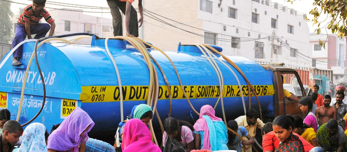
 An acute shortage of piped water supply has led to dependence on water tankers at this locality in Delhi, India.
In 2018, Cape Town made headlines as the world’s first major city to approach ‘Day Zero’ when the city would run out of water.
Shortly thereafter, an acute water crisis brought Shimla to a halt. Those were one-off events, we thought. Until this summer, when Chennai had to bring water by train from more than 200 km away.
On the flip side, unprecedented floods ravaged Kerala last year. This year, large parts of India were devastated by the deluge.
Today, however, the challenge is of a different magnitude altogether.
To make matters worse, climate change is playing out in ways we don’t yet fully understand. The country is now reaching a tipping point. Groundwater resources in more than half of India’s districts are critical or overexploited, and some rivers are not reaching the sea.
India, as a whole, is not a water-scarce country. Even though the availability of water per person has fallen from 4,000 cubic meters in 1950 to around 1,000 cubic meters today, India still has far more water per person tthan Israel, for instance.
Yet, despite its arid climate, Israel has increased water security with just around 90 cubic meters of water per capita.
Accurate data can help India better manage its water resources
It’s not so much a water crisis, therefore, as a water management crisis, calling for a paradigm shift in the way we manage things. The key to managing water efficiently is having accurate, real-time data. As the saying goes, if you can’t measure it, you can’t manage it.
For a start, we need to know how much water the country has, where it has it, when it has it, and how this water is being used. Only then will we be able to assess the demand from various sectors, harness water from every possible source, and plan its use judiciously.
The online platform indiawris.gov.in – launched in August - has made this easier. Users can now access the entire country’s water data - both historic and real-time - on a state and basin-wide basis.
Because, when dealing with such large volumes of water, even the smallest mistakes can have devastating consequences downstream.
Although collecting water data is not new for India, it has often been difficult to use it, either because various water agencies used different formats to store their data or were reluctant to share it with each other.
But now, reservoir operators will be able to employ this data to run different models on a real-time basis and use decision support systems to determine which reservoir to release water from, how much to release, and when. This will allow them to maximize water storage while preventing flooding downstream.
In a few years, it will be possible to accurately determine which villages will be flooded when river levels rise. This will enable urban planners to avoid development in flood-prone areas and remove encroachments from places where communities might be at risk.
The importance of consistent, transparent, and easily accessible water data cannot be overemphasized in India where over 5,000 medium and large dams are spread across the country.
More importantly, planners will be able to take a basin-wide approach to better manage the fragile ecology of river basins.
This will also allow them to adjudicate fairly in river water disputes, as the digitization of water data will make the system more transparent, and hopefully increase trust among stakeholders.
Agriculture departments too will be able to give farmers customized advice such as which crop to plant, where, and when, depending on the volume of water in the reservoirs and ponds in their area. Until now, this has been a big challenge.
Decisions about where and what kind of rain-water harvesting structures, such as check dams, to build can also be made more transparently. What's more, it will now be possible to assess the impact these structures will have downstream, as many a time the construction of upstream structures dries out areas downstream. (This practice is already being followed in the World Bank-supported West Bengal Accelerated Development of Minor Irrigation project.)

And this is just the beginning.
In the years to come, information about the quality of surface and groundwater will help map the areas where water is unsuitable for drinking or other purposes.
Artificial intelligence will also be able to put this voluminous data to use to better understand the impact of climate extremes and help devise appropriate solutions.
Today, however, these interventions are crucial. For the need of the hour is efficient and sustainable water management that can meet the needs of the present without compromising the future for coming generations


Join the Conversation