")
The alarming decline in biodiversity demands immediate attention. Over the past few decades, our planet has experienced unprecedented biodiversity loss, posing a serious threat to environmental health and our future. The Intergovernmental Science-Policy Platform on Biodiversity and Ecosystem Services (IPBES) warns that nearly one million species face extinction if current trends continue. To ensure sustainable development and ecosystem resilience, we must act swiftly to protect biodiversity.
Human activities are significantly altering ecosystems around the globe. The expansion of human infrastructure has led to widespread habitat loss, environmental degradation and a decline in biodiversity. The clearing of forests, wetlands, and other critical habitats for agriculture and urban development is pushing numerous species toward extinction. As human settlements encroach on wildlife habitats, conflicts can arise, resulting in crop damage and safety concerns that may further intensify threats to species when humans retaliate. Exploitative practices, including deforestation, mining, and overfishing, deplete vital resources, while pollution contaminates essential ecosystems. Moreover, poaching and illegal trade in wildlife exacerbate these challenges, driving many species to the brink of extinction and undermining conservation efforts. Addressing these pressing issues requires innovative solutions, such as sustainable land use and the establishment of wildlife corridors.

Fostering human-wildlife coexistence is essential for protecting biodiversity. Protected areas and community-based conservation initiatives play crucial roles in maintaining species survival and ecosystem balance. By engaging local communities, we can promote stewardship and sustainable practices that mitigate conflicts and enhance both human and environmental well-being. Effective measures, including habitat preservation, land-use planning, legal protections, and research on coexistence are crucial for achieving sustainable coexistence that benefits both people and nature.
We have developed the Human Coexistence Indicators (HCI) to measure human influence on terrestrial, freshwater, and marine environments. Key metrics, including population density, land use, water consumption, infrastructure and pollution, utilize open-access global spatial data to reflect natural resource use, production, mobility, accessibility, and pollution. We aggregated indicators for these variables into 0.25-degree global grids and normalized each on a scale from 1 to 100, where 100 represents maximum human impact.
We have also developed a composite HCI that combines information from individual indicators to provide an overall view for each grid cell. Among the standard measures of central tendency, we have chosen the geometric mean of the individual indicators, because it is less influenced by outlier values than the arithmetic mean while drawing on more distribution information than the median.
The composite HCI for a grid cell is integrated with its total species count to provide a nuanced understanding of human influence in species-rich areas. This integration involves overlaying composite HCIs with species counts from the World Bank’s recently published Global Biodiversity Database, constructed using species occurrence reports from the Global Biodiversity Information Facility (GBIF). The database includes nearly 600,000 vertebrates, invertebrates, plants and other species across terrestrial, freshwater, and marine ecosystems.
Combining the HCI with species counts provides an overall indicator for comparative analyses of human influence in species-rich areas at both global and regional levels. The overall indicator also highlights priority areas for conservation and sustainable management, effectively integrating human impact data into policy decisions.
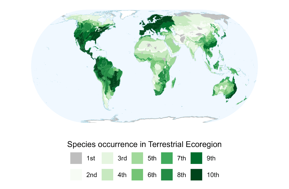
Mapping the HCI provides critical insights into the distribution of species and human influence across different ecoregions. Darker shades on the maps indicate areas with higher concentrations of species or greater human impact from these measures across terrestrial, freshwater, and marine ecosystems:
- Terrestrial: High human influence dominates regions like China, India, and France, while low influence prevails in areas such as Algeria and central Australia.
- Freshwater: Key regions of high human impact include China, Italy, and South Africa, contrasted by low-impact zones in Mongolia and Russia.
- Marine: Areas with intense human influence include Vietnam and Qatar, while Iceland, Canada and Samoa exhibit minimal impact.
The HCI framework is adaptable for various geographic contexts and offers extensive customization options. Designed to be scalable, this framework allows users to incorporate different geographic boundaries, such as subnational areas or specific ecoregions, depending on available data. While our analysis utilizes global data, the framework's adaptability enables practitioners and policymakers to address local environmental issues as well. Users can select geographic scales relevant to their needs, focusing on ecoregions or administrative units of interest. Additionally, they can explore specific indicators or adjust aggregation methods to gain deeper insights into human impact. Users can also choose alternative biodiversity indicators; for example, instead of species richness, they can consider location-specific critical biodiversity metrics such as the count of endemic species, species with small occurrence regions, or those at a high risk of extinction. This flexibility empowers stakeholders to tailor the framework to meet their unique contexts and challenges.
In conclusion, the HCI can serve as a vital tool for monitoring human-nature interactions and empowering context-specific solutions. By capturing the complexities of human influence on ecosystems, this comprehensive approach enables informed decision-making for conservation and sustainable management efforts. Its multiple customization options and scalability equip users to address diverse ecological and conservation challenges, ensuring relevance across different contexts—from local conservation efforts to global biodiversity monitoring. As we strive to balance human activities with the health of natural systems, we expect that the HCI framework will play a crucial role in promoting biodiversity preservation and fostering coexistence through data-driven decisions that align with specific needs.
For our Spatial HCI Datasets, visit
1. Terrestrial Human Coexistence Index
2. Freshwater Human Coexistence Index
3. Marine Human Coexistence Index
If you’re interested in our research on Species Occurrence Regions, please see Revisiting Global Biodiversity: A Spatial Analysis of Species Occurrence Data from the Global Biodiversity Information Facility, World Bank Policy Research Working Paper 10821.
Acknowledgements:
Data Sources for Species Occurrence:
- GBIF Occurrence Download. Accessed from GoogleBigQuery on 2024-02-17.
- Global Biodiversity Species Global Grid. 2024. World Bank Development Data Hub.
Data Sources for Human Coexistence Indicators (HCI)
The Terrestrial HCI is based on several key data sources, including population density from WorldPop (2018), Agricultural GDP by Ru et al. (2024), and land cover classifications from HYBMAP data (Zhu et al. 2024). It also incorporates mining density (Maus et al. 2022), road infrastructure data from the Global Roads Inventory Project (Meijer et al. 2018), and travel time to cities over 50,000, v4 (Nelson 2019), alongside Harmonized Nighttime Lights data, v2 (Li et al. 2020).
For Freshwater HCI, the sources include population density from WorldPop (2018) and river-related metrics—such as water consumption and connectivity—from a global dataset of over 12 million kilometers of rivers (Grill, Lehner et al. 2019).
The Marine HCI utilizes near-real-time fishing effort data from Global Fishing Watch (Kroodsma et al. 2018), satellite imagery at a 0.10 decimal degree resolution (Paolo et al. 2024), population data from the Gridded Population of the World, v4 (SEDAC/CIESIN 2023), and insights from the IMF’s World Seaborne Trade monitoring system (Cerdeiro et al. 2020), along with ocean microplastic concentration data (Evans and Ruf 2021).
The authors gratefully acknowledge financial support from the Global Environment Facility.


Join the Conversation