The COVID-19 crisis is projected to push an additional 10 million people into poverty in Nigeria by 2022; combined with population growth, this could leave more than 100 million Nigerians living below the national poverty line. This motivates the government’s ambitious aspiration to lift 100 million Nigerians out of poverty by 2030.
Prior to the pandemic, social protection programs—which could help Nigerian households weather the effects of the COVID-19 crisis—had limited coverage. According to the 2018/19 Nigeria Living Standards Survey (NLSS), just 1.6% of Nigerians lived in a household that was enrolled in the National Social Safety Net Project (NASSP), the country’s flagship social protection program. As is the case in other countries, those Nigerians newly impoverished by the COVID-19 crisis are likely to be different from the existing poor: they are more urban, more likely to live in southern Nigeria, and more dependent on service sector incomes. This evolving profile of the poor is reflected in current efforts to expand social protection in Nigeria, including the Rapid Response Register for the COVID-19 Cash Transfer Project, which is being guided by the mapping exercise described below.
‘Poverty maps’, which show the specific communities in which poor people live, can substantially improve geographic targeting to help extend social protection. Historically, such poverty maps have relied on small area estimation to estimate the poverty of small regions using a combination of household surveys and censuses. Yet Nigeria’s most recent census was in 2006, so a new and improved approach is needed.
To provide more up-to-date and more granular poverty estimates for Nigeria, recent advances in deep learning were used to construct a high-resolution poverty map from satellite imagery and other sources of geospatial Big Data. These techniques work by “learning” how to predict poverty by being exposed to a large dataset that matches ground-truth labels of poverty (from geo-located household surveys) to imagery and other geospatial data. Intuitively, the algorithms learn the visible features that are predictive of poverty, such as road quality, building density, and land topology (see Figure 1).
Figure 1. Using deep learning to construct a high-resolution poverty map from satellite imagery and other sources of geospatial Big Data
Note: Colors in the map on the right-hand side correspond to an estimated wealth index. Source: Chi et al. (2021) for wealth estimates[1]; National Social Safety Nets Coordinating Office for shape file; and 2018 DHS.
After constructing these poverty maps, they were carefully validated in Nigeria, using several independent sources of survey data. In particular, the original poverty maps were trained using data from the nationally representative 2018 Demographic and Health Survey (DHS), but were cross-checked and validated using the 2018/19 NLSS. This step is vital because the 2018/19 NLSS is the survey used to calculate Nigeria's official poverty and inequality statistics. These validation exercises confirm that there is a strong correlation between the welfare estimates from the machine learning approach and those of the 2018/19 NLSS (see Figure 2). In this sense, far from replacing existing household surveys, digital solutions build on the solid foundations provided.
Figure 2. Validation of the accuracy of the high-resolution poverty maps, produced using Big Data and machine learning
Note: Validation exercise applied at the local government area (LGA) level. “Satellite estimates” refer to outputs from Big Data and machine learning techniques. Source: Smythe and Blumenstock (2021).[2]
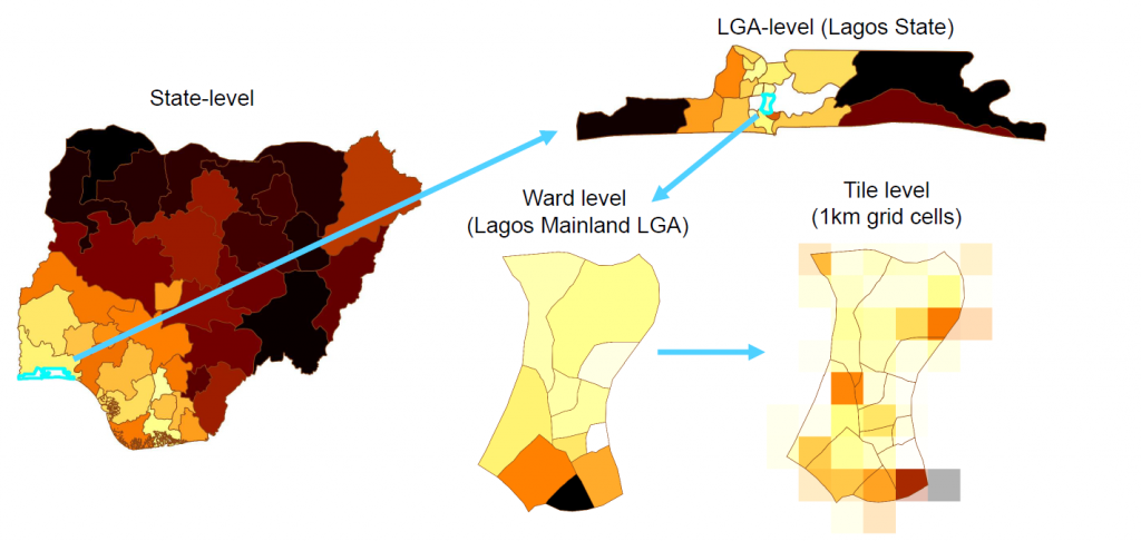
The new poverty maps show that there are “pockets of poverty” even within relatively wealthy areas of Nigeria. The share of the population living below the national poverty line is almost three times larger in northern Nigeria than in southern Nigeria, and Lagos—in Nigeria’s South West zone—has the lowest poverty headcount rate of any state in Nigeria at 4.5%. Yet within Lagos, there are specific vulnerable communities in which households may fall (further) into poverty without support from social protection systems as the COVID-19 crisis evolves (see Figure 3).
Figure 3. Pockets of poverty persist even within some of Nigeria’s richer areas, including Lagos

Source: Chi et al. (2021) for high-resolution poverty estimates; National Social Safety Nets Coordinating Office for shape file, 2018 DHS, and 2018/19 NLSS.
These ward-level poverty maps are useful for targeting social protection programs to communities, but digital solutions may offer further promise for identifying vulnerable households within these communities. For instance, in ongoing work being done by researchers from the University of California, Berkeley and Innovations for Poverty Action, GiveDirectly and the Government of Togo are using information collected by mobile phone operators to target cash transfers to the poorest individuals in the country. Such work requires careful attention to privacy concerns and potential exclusion errors due to heterogeneous mobile phone ownership, but offers great potential to distribute support quickly and at scale.
This poverty mapping exercise exemplifies the “moonshot” approach Nigeria can adopt to harness the rise of digital data to improve its data landscape more quickly and more cheaply. Investing in such data can help policymakers in Nigeria respond to the COVID-19 crisis and build back better.


Join the Conversation