 flooding in tanzania
Urban areas are increasingly prone to flooding due to climate change, rising urbanization, and inadequate stormwater management. A recent paper estimated that 1.81 billion people, or 23% of the world population, are directly exposed to a 1-in-100-year flood event, posing significant risk to lives and livelihoods. As climate change further disrupts weather patterns, river flows, and sea levels, it is essential that cities develop strategies and plans to deal with the associated risks. Therefore, assessing urban flood risk is crucial to help ensure the safety of urban residents and prevent flood events from causing costly damage to infrastructure and local economies.
Urban flooding is a highly complicated problem to address, requiring deep technical expertise and complex engagement with many stakeholder groups. Cities often lack the know-how to fully gauge and act on the danger they face. By conducting urban flood risk assessments, local governments can better understand and manage their flood risk. This helps protect the lives, livelihoods, and assets of their communities and plan for long-term changes such as sea-level rise or increased storm frequency. By evaluating the probability of future flooding and the impact of different potential gray and green engineering solutions, such assessments provide valuable information for decision-makers allocating funds and other resources to flood preparedness and resilience programs.
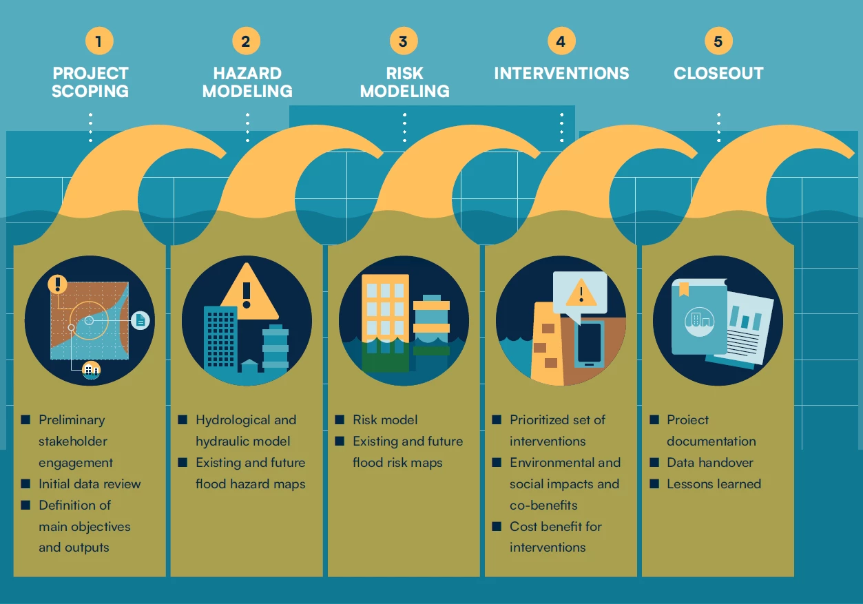
The new Urban Flood Risk Handbook: Assessing Risk and Identifying Interventions, developed by the City Resilience Program at the Global Facility for Disaster Reduction and Recovery, offers practical guidance and best-practice methods for conducting an urban flood risk assessment and appraising options for mitigating flood risk. Designed for project managers, technical practitioners, local stakeholders, and anyone interested in strategic studies of urban flooding, the Handbook is enriched by case studies from six countries. It provides insights to help cities prepare for the increasingly frequent and severe floods around the world. By democratizing access to this highly specialized field for a broader audience, the Handbook also aids in scaling up the practice of high-quality flood risk assessment in cities globally. Key principles the Handbook highlights for developing urban flood risk assessments include:
Defining the aim and scope of the study
- Develop a clear understanding of the aim and scope of the assessment from the start, including defining the intended audience and geographical extent, and involve all relevant stakeholders early on.
- Consider the required effort (in time and cost) relative to the accuracy and resolution needed for the study, recognizing the important tradeoff between the two.
- Understand that the accuracy of the hazard and risk assessment heavily depends on the quality and availability of underlying data. Such data can be expensive and time-consuming to collect or purchase and should be examined as early as possible.
- Centralize stakeholder engagement in the process of assessing flood risk and appraising risk mitigation options to validate results and processes and ensure the uptake and support of the options.
Flood hazard and risk assessment
- Understand the local drivers of flooding – including high river discharges, local rainfall, extreme tides, and cyclone-induced storm surge – and the possibility of their joint occurrence in an urban area.
- Establish robust hazard and risk results sense checks at key stages, conducted by experienced and knowledgeable personnel, especially where adequate calibration or validation is challenging in data-poor environments; if necessary, global data may be used to validate outputs.
- Examine any remaining hazards and risk assessment uncertainties when evaluating intervention options and clearly disclose them when communicating findings.
Evaluation of potential interventions
- Adopt an open-minded and structured approach to consider all potential interventions across the gray-green-blue infrastructure spectrum, as well as non-structural options.
- Evaluate and account for both the direct benefits (e.g., reduced damage, fewer affected people) and the co-benefits (e.g., environmental, economic) of solutions.
- Analyze interventions against various future climate change and socioeconomic scenarios, prioritizing solutions effective across a broad range of potential situations.
- Consider the interaction of neighboring interventions with each other, accounting for the possibility of negative impacts as well as cumulative benefits.
- Assess the potential environmental and social impacts – including resettlement and land acquisition – of identified solutions early in the decision-making process to sidestep potential pitfalls later.
Grounded in detailed technical expertise, the Handbook assists governments and other stakeholders in enhancing the quality and actionability of urban flood risk assessments. Its comprehensive practical guidance and wide application range facilitate scaling in adapting to and mitigating the impact of urban floods, ensuring cities remain resilient in a changing climate.


Join the Conversation