Follow the author on Twitter:
@tatipq
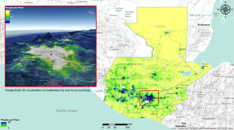
Modeled 2012 population in Guatemala at a spatial resolution of 100 m2 People are at the center of all development work: whether we act to prevent and address disasters, protect vulnerable communities, finance projects in infrastructure, education or health, our ultimate goal is always to serve people. Being able to identify, understand and locate beneficiaries as accurately as possible is an essential first step in that process, and the only way to make sure we provide services to those who need it most with maximum impact.
Inside the World Bank, the number of people passionate about using spatial data for development speaks to the relevance of spatial datasets in supporting critical decision making. In an effort to use spatial data more strategically, we recently conducted an informal poll among several Bank units and some partner institutions to find out what types of spatial data are most relevant to development professionals.
This survey found that the spatial distribution of the population was a key data layer needed by Bank staff. The results of the survey showed that that while national level data are useful, subnational detail on administrative boundaries, trade & transport infrastructure, population distribution and socio-economic data down to the city level are just as critical to the majority of respondents.
Similar surveys are being conducted to evaluate the needs of other public and private sector stakeholders: the Open Geospatial Data for Energy Access Survey, for instance, was launched recently by the World Bank Group in collaboration with the European Space Agency to identify geospatial data needs in the energy access field. Preliminary results emphasize that openly accessible, higher resolution data on population locations and densities play a critical role in rationalizing and prioritizing efforts (and investments).
In that context, there’s one initiative that has the potential to fulfill the need for better spatial data: WorldPop. Andy Tatem, Associate Professor at the University of Southampton and founder of WorldPop visited the Bank a few weeks ago to share his team’s work. WorldPop disaggregates census population counts within subnational administrative boundaries by modeling likely locations at a spatial resolution of 100 m 2. Originally developed for fighting malaria, WorldPop has been financed primarily by the Gates Foundation.
In order to bridge the data gap for low- and middle-income countries, WorldPop has been working with statistical agencies, health departments, etc., to obtain the finest detail, boundary-matched census data and has developed a methodology for integrating ancillary data sources to fill data gaps in census. All the while, they have integrated new technologies and data sources to their model, and have made all their data and methodology freely available. This type of good practice is in line with modern Open Data principles condoned by the World Bank.
The model utilized by WorldPop, Random Forest Classification and Regression utilizes a ‘Machine Learning’ approach which is robust to outliers and noise. Furthermore, it provides useful internal estimates of error, strength, correlation and variable importance, has built-in cross-validation and is easily parallelized.
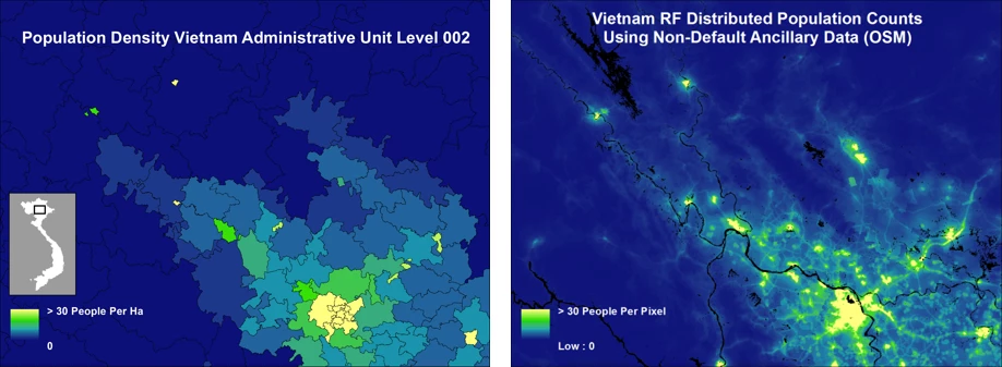
Population density in Hanoi, Vietnam at the district level (map 1) vs. with 100-meter resolution used by WorldPop (map 2).
The second map provides a much more detailed picture of population density, including variations of density within each district. Overall, it is fair to say that WorldPop channels many of the elements that have become essential to the work of development professionals: high resolution spatial distributions, rigorous methodologies and open-source documentation. For the World Bank’s urban development experts, the global population distribution map, coordinated with the map of built-up areas, will for the first time allow for an international comparison of national urban populations that does not rely on varying national census definitions, population counts or density measurements.
More generally, having a global map of population distribution will allow all our teams and development partners to plan, target and monitor our projects more effectively while making sure that we are reaching the right people — wherever they might be.
Modeled 2012 population in Guatemala at a spatial resolution of 100 m2
Inside the World Bank, the number of people passionate about using spatial data for development speaks to the relevance of spatial datasets in supporting critical decision making. In an effort to use spatial data more strategically, we recently conducted an informal poll among several Bank units and some partner institutions to find out what types of spatial data are most relevant to development professionals.
This survey found that the spatial distribution of the population was a key data layer needed by Bank staff. The results of the survey showed that that while national level data are useful, subnational detail on administrative boundaries, trade & transport infrastructure, population distribution and socio-economic data down to the city level are just as critical to the majority of respondents.
Similar surveys are being conducted to evaluate the needs of other public and private sector stakeholders: the Open Geospatial Data for Energy Access Survey, for instance, was launched recently by the World Bank Group in collaboration with the European Space Agency to identify geospatial data needs in the energy access field. Preliminary results emphasize that openly accessible, higher resolution data on population locations and densities play a critical role in rationalizing and prioritizing efforts (and investments).
In that context, there’s one initiative that has the potential to fulfill the need for better spatial data: WorldPop. Andy Tatem, Associate Professor at the University of Southampton and founder of WorldPop visited the Bank a few weeks ago to share his team’s work. WorldPop disaggregates census population counts within subnational administrative boundaries by modeling likely locations at a spatial resolution of 100 m 2. Originally developed for fighting malaria, WorldPop has been financed primarily by the Gates Foundation.
In order to bridge the data gap for low- and middle-income countries, WorldPop has been working with statistical agencies, health departments, etc., to obtain the finest detail, boundary-matched census data and has developed a methodology for integrating ancillary data sources to fill data gaps in census. All the while, they have integrated new technologies and data sources to their model, and have made all their data and methodology freely available. This type of good practice is in line with modern Open Data principles condoned by the World Bank.
The model utilized by WorldPop, Random Forest Classification and Regression utilizes a ‘Machine Learning’ approach which is robust to outliers and noise. Furthermore, it provides useful internal estimates of error, strength, correlation and variable importance, has built-in cross-validation and is easily parallelized.
Population density in Hanoi, Vietnam at the district level (map 1) vs. with 100-meter resolution used by WorldPop (map 2).
The second map provides a much more detailed picture of population density, including variations of density within each district.
More generally, having a global map of population distribution will allow all our teams and development partners to plan, target and monitor our projects more effectively while making sure that we are reaching the right people — wherever they might be.

Join the Conversation