 Aerial view of a maritime cargo ship in motion and producing a wake in the surrounding water. Photo: GreenOak/Shutterstock
Seventy percent of the Earth’s surface is covered by water. Every day, tens of thousands of ships cross our seas and oceans, carrying the vast majority of traded goods. Despite the strategic importance of international marine trade, governments find themselves with limited or incomplete data to inform relevant policies. Can we shed more light on the oceans by capitalizing on ship movement data for economic analysis and sustainable development? Thanks to a repurposed data flow, powerful algorithms, and the commitment of international organizations to open data, the answer is yes.
For navigational safety purposes, the International Maritime Organization requires most ships to carry a device commonly known as AIS (Automatic Identification System). Satellites and terrestrial stations capture the location reporting radio signals these devices routinely emit, resulting in thousands of daily observations per vessel. The AIS data signals broadcast a range of information including a ship’s position, speed, category, and water depth.
A fruitful partnership on AIS data
Recently, the International Monetary Fund (IMF) and the World Bank undertook a joint effort to harness the wealth of information generated by AIS messages and determine whether these insights can inform trade analysis, development work, and public policies.
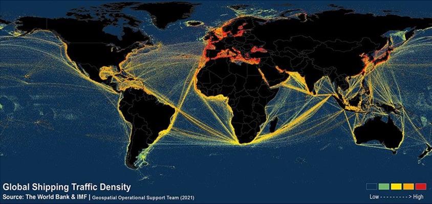
Using various machine-learning and spatial data processing techniques, we mapped out years of vessel AIS data to uncover shipping lanes and derive trade volume estimates. So far, our analysis has resulted in new, open-access datasets providing high-frequency seaborne trade estimates and showing Global Shipping Traffic Density on a global scale.
These new datasets have already informed trade nowcasting and marine spatial planning—see the two examples below—and will undoubtedly provide the basis for further analyses and public policies in the future.
Trade nowcasting with near-real-time data
Policymakers often need to know what is happening to the economy in real-time, but they frequently must settle for data that provides insights only into what happened weeks ago. International trade, which links countries through a complex web of supply chains, is an area where timely information is especially valuable for improved analysis and decision making.
That is why we have developed a new methodology to track maritime trade developments using AIS data at the International Monetary Fund. The methodology applies various machine learning algorithms to AIS messages to identify vessels’ port-to-port voyages and to estimate trade volumes.
Since AIS data can be processed in near-real-time, the estimates have proved especially useful around big turning points in global trade, such as the onset and recovery from the COVID-19 pandemic. The data has also allowed the timely analysis of the trade effects of lockdowns and has provided insights into recent supply chain disruptions due to port congestion.
Marine spatial planning: helping plan offshore renewable energy development
Beyond trade analysis, AIS data can provide important insights into development policy as well. Careful placement of offshore wind farms is essential to ensure the sustainable, responsible, and safe use of ocean winds. In this context, the placement of offshore wind projects needs to minimize the potential risk that ships may collide with wind turbine structures.
The World Bank Group’s Offshore Wind Development Program helps developing countries harness their offshore wind potential. With support from the World Bank’s Energy Sector Management Assistance Program (ESMAP) and PROBLUE, the Offshore Wind Development Program is mapping the seas to identify promising areas for wind farms in developing countries. This mapping utilizes the Global Shipping Traffic Density data to identify heavily trafficked sea areas where offshore wind cannot be developed.

Open access to provide a public good
The two examples described in this blog are merely a fraction of the applications that our derived data and estimates can help inform. This is why we have committed to publicly disseminating our data, analysis, and findings—so that our efforts can spur new applications around the world.
Trade volume estimates are available to browse and download through a collaboration with the United Nations’ COMTRADE division, and they have been used by researchers in academia, policy institutions, and private companies. With over 8,300 downloads in less than six months since publication, open datasets, such as the Global Shipping Traffic Density spatial layers, open numerous possibilities for supporting efforts such as the conservation of marine areas, managing the coexistence of marine activities, and informing the sustainable use of our seas. And, following the success of these datasets, the World Bank’s Development Data Group is currently working on developing an open toolset for analyzing AIS shipping data.


Join the Conversation