 أضواء الليل في ووهان، الصين. حقوق الصورة: Benjamin Chris / Unsplash.
Images of Earth taken at night are revolutionizing our ability to measure and understand nearly every dimension of human activity on Earth and allow us to get a glimpse into human-Earth interactions in close to real time. The COVID-19 outbreak exemplifies how nighttime lights can help understand the impacts of shocks on populations, economies, and markets.
Given the interdisciplinary nature of remote sensing–based socioeconomic research, a Special Issue of Remote Sensing will bring together original and novel studies demonstrating innovative applications of analyses based on nighttime lights, to help broaden our understanding of human activity, how it’s changing, and a wide range of implications.
Seeing the Impacts of COVID-19 at Night
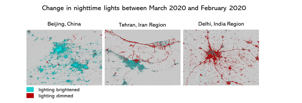
In mid-December 2019, COVID-19 began emerging in Wuhan, China, and rapidly spread, causing significant impacts not only on people’s health, but on the entire economy, the job market and the daily life across the country. Within several weeks the disease was spreading globally, with millions of confirmed cases recorded around the world and significant implications for the global economy.
The need to track and predict outbreaks, as well as understand the impacts of COVID-19 on economies, has led to the utilization of unique sources of data that could help track the spread of the pandemic in close to real time. Satellite observations - including those taken at night - are becoming a primary source of data for tracking the progress of the pandemic and its impacts on energy consumption, transportation, social interactions, the functionality of critical infrastructure, tourism, trade emissions, etc. These images provide a compelling and striking picture of the large-scale impacts of COVID-19 on Earth, from the impacts of the pandemic on businesses and transportation networks to monitoring the gradual recovery of cities around the world.
The idea of using nighttime lights to understand pandemics is not new, and previous studies have already shown, for example, how nighttime lights can be used to estimate seasonal measles epidemics, which are directly linked to spatio-temporal changes in population density as measured by anthropogenic light emissions.

Shedding Light on Earth
The use of nighttime lights observations to monitor pandemics is only one example of how satellite observations can be used to help us better understand processes on Earth. Since the early 1990s, with the launch of DMSP-OLS, remotely sensed observations of nighttime lights have been a key instrument for understanding almost every aspect of human activity on Earth, particularly in the data-scarce region, without needing to be filtered through national data agencies.
Today, newer sensors, such as VIIRS/DNB, provide nighttime light data at an even higher spatial resolution and granularity. With advances in the availability and the quality of nighttime light data, together with improvements in data storage capabilities and the development of new analytical methods and workflows for analyzing the data, there is an ongoing increase in the number of scientific applications that exploit remotely sensed nighttime lights to measure our world.
Nighttime lights observations – or measurements of the intensity of light emitted from Earth at night - provide a unique glimpse into human behavior and socioeconomic patterns as well as into the nature of human-Earth interactions. These observations are especially vital in countries where timely, accurate, and reliable statistical or administrative data is poor. Here, nighttime light measurements can provide important insights into where people are and how they move; they can also help us understand patterns of economic development or evaluate the economic impacts of investments in infrastructure.
While in some cases, nighttime light observations may carry inherent measurement errors especially when compared across space and time, there is a general consensus that nighttime lights are able to represent many dimensions of human presence and activity on Earth.
Today, nighttime lights are being used to measure the extent and characteristics of urbanization processes; estimate economic growth at both national and subnational levels; map global poverty as well as population density, migration and mobility patterns; track local household wealth, education and health; understand armed conflicts; measure access to electricity and electrification as well as community resilience, fishing activity, coral reef health, and more. Recently, researchers have also shown that nighttime lights can even help explain brain development and human behavior.
Moreover, by looking at the relation between the distribution of the population on Earth and the occurrence of different types of hazards, nighttime lights measurements can be used to evaluate how humans adapt and respond to these hazards. This makes them useful as an instrument to guide resilience planning. For example, the City Resilience Program utilizes nighttime light data in its City Scan product to highlight where hotspots of economic activity may be developing in flood-prone areas.

While COVID-19 is creating a new demand for what these observations can tell us, the insights they enable will also be important inputs into many aspects of countries’ recovery when the health emergency subsides.


Join the Conversation