 City of Sarajevo
Cities are at the forefront of understanding risks and devising ways to manage them. Cities worldwide are grappling with the impacts of climate change. Extreme weather events are on the rise, putting dense urban centers with their high concentrations of people and capital, in the line of fire. Cities, however, also hold one of the keys to protecting citizens from their impacts and creating safer environments – to keep them thriving.
Consider Sarajevo and Hiroshima – two cities, in seemingly disparate parts of the world. Yet, they share many parallels. They’ve both bounced back from the devastating impacts of war and face similar geographical challenges with their majority mountainous terrain. Their residential areas have expanded into hilly lands susceptible to landslides. Recognizing these similarities, officials from both cities joined hands to exchange knowledge on managing landslide risks.
Understanding the risks
Sarajevo, the capital city of Bosnia and Herzegovina, confronts growing development pressures in hilly urban areas. The Canton of Sarajevo houses close to 1/8th of the country’s population while mountainous terrains occupy over 60% of the territory. Sarajevo is no stranger to managing landslide risks. But challenges remain, including stemming construction in high-risk hilly areas.
Meanwhile, Hiroshima, the 10th most populated city located in western Japan has over 80% of its land covered in hills and mountains. Since the 1950s, early settlements in valleys developed along the hilly slopes, away from the flood plain of the Ohta River, where flood protection was not fully implemented. The rapid population increase in the 1970s brought with it further expansion into hilly suburbs. Recognizing the danger, Hiroshima demarcated zones in the mountains above which construction was prohibited. At the same time, a flood embankment was installed to make the low-lying areas safer, turning farmlands near the river into new residential areas. But even with these regulations, Hiroshima wasn't immune to natural hazards, as the devastating mudflows in 2014 demonstrated. Consequently, the city has been diligent in its risk mitigation efforts against landslides and mudflows.
After a series of initial discussions with Japanese stakeholders, the City of Hiroshima was identified as the best city to share knowledge and experience on landslide risk management. A virtual dialogue was organized with support of the World Bank's Global Facility for Disaster Reduction and Recovery (GFDRR) and its Tokyo DRM Hub through the Japan-World Bank Program for Mainstreaming Disaster Risk Management in Developing Countries, and the Tokyo Development Learning Center, which recently welcomed Hiroshima as the 7th city in its City Partnership Program.
Combining hard and soft measures
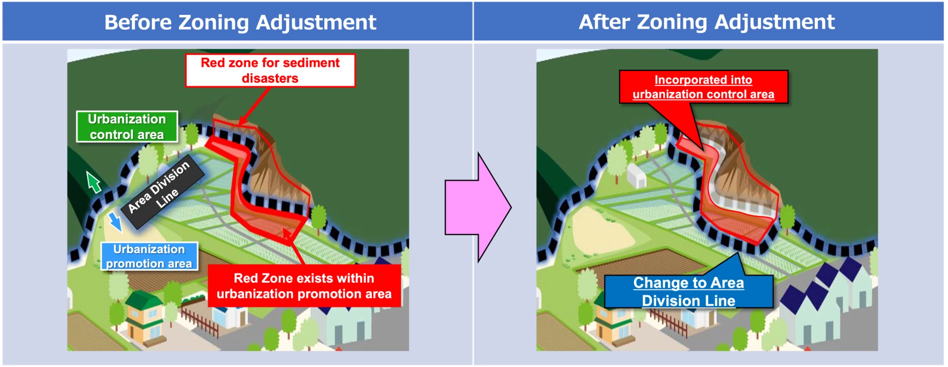
The virtual dialogue highlighted comprehensive approaches to landslide risk management with a focus on soft measures. In Japan, the legal and institutional framework pertaining to landslide risk management is set by the national government, while the local governments lead the implementation of the policy. Based on risk assessment of areas susceptible to geohazards (including landslides, mudflows, and slope failures), the key to protecting lives lies in combining hard infrastructure with non-structural measures , like risk-informed zoning, hazard mapping, development permit, inspection, risk awareness, and training.
In Japan, two types of zoning, one on development control and the other on risk-based hazard (red) zones, guide safe urban development. Hiroshima, given its topographical challenges, has the highest number of these red zones. Buildings in these areas must meet stringent safety standards, and frequent inspections ensure that these standards are upheld. The coordination of the two zoning is essential to restrict new developments in high-risk areas.
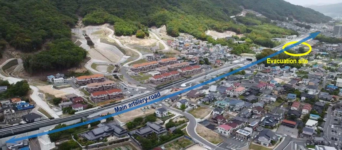
Even strictly enforced development regulations are no match for extreme weather events. In 2014, Hiroshima experienced unprecedented torrential rains, with 280 mm of rainfall within 24 hours, taking 77 lives and affecting nearly 5,000 homes. Following this event, a revised evacuation plan was implemented with the introduction of wide evacuation roads and additional shelters to protect more lives in the face of such extreme events. Residents have played an important role in proposing infrastructure improvement plans, raising risk awareness with hazard maps, and conducting regular evacuation drills.
Knowledge exchange inspiring safer practice
For Sarajevo, Hiroshima’s experiences provided critical insights into how to bolster defenses against landslides and mudflows. The workshop participants in lively interactions and discussed the challenges and ways to best implement risk identification, zoning, and development controls comprehensively. The key focus of the discussion was how to proceed with development in the so-called “red zones.” Getting permits for new developments in red zones is virtually impossible in Japan, while the re-development of existing residential areas that were deemed unsafe requires adherence to strict physical reinforcement standards. Could such approaches work in Sarajevo?
Sarajevo has focused, rightly so, on designing good policies. The renewed focus should now be on implementation. The workshop helped to showcase ways in which this could be done. Participants found similarities between the two cities in areas of risk identification, monitoring, and construction techniques. Rigorous implementation of disaster risk mitigation measures, led by relevant agencies and local government units, can ensure houses and people are protected against risks . Reflecting on the workshop, Ms. Maida Zejnić, an expert advisor at the Institute for Development Planning of Canton Sarajevo, shared that learning policy and technical lessons from Hiroshima was useful and expressed the desire for continued engagement with Hiroshima, especially given their similar geographical challenges.
Conversely, Hiroshima participants gained insights into the universality of urban challenges, irrespective of geographical location. They recognized that lessons drawn from their experiences can be invaluable for cities facing the twin challenges of urbanization and climate change.
As cities across the globe grapple with the specter of climate change, collaborations like the one between Hiroshima and Sarajevo underscore the importance of knowledge exchange. Such dialogues pave the way towards building more resilient urban environments.


Join the Conversation