 持続可能な開発シリーズ
Building a Balanced Future is a new World Bank series that learns from COVID-19 and offers expert insights into building a sustainable, inclusive world that is more resilient to shocks.
The coronavirus pandemic has cast a light on social and spatial disparities within cities like never before. A major concern is a city’s economic geography: the interplay between its economic and physical setting.
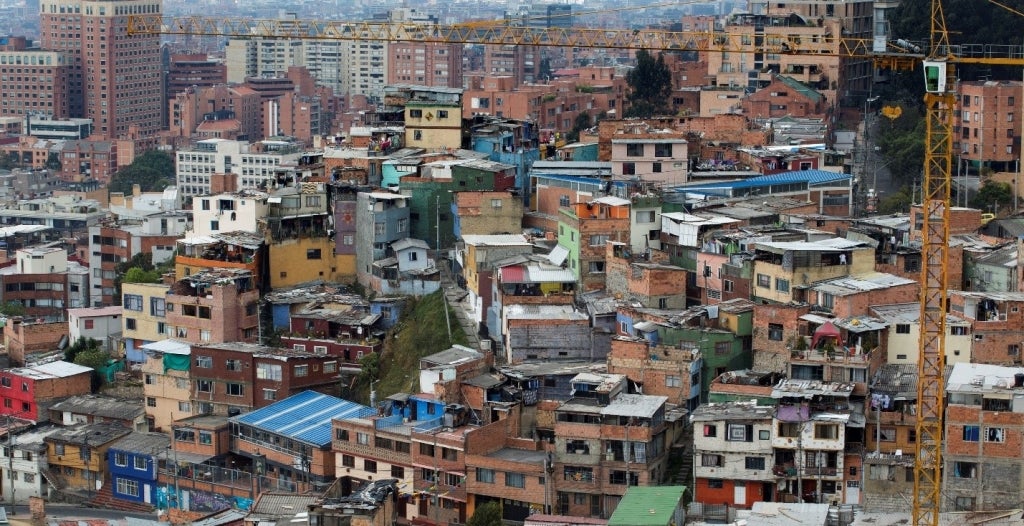
For example, many urban dwellers in Africa and Asia live in slums and informal settlements. Even in the best of times, these environments are beset by cramped living conditions, limited public space, and inadequate public services. But amid a global pandemic like COVID-19, these conditions make for a hotbed of viral spread.
Mitigating measures such as handwashing and self-quarantining are severely limited. How can you maintain a safe distance from others when space is limited or communal facilities bring you into close contact with neighbors? It is mind-boggling, for example, to think of the contagion risk it presents when 68,400 people without household toilets or taps are packed together on one square kilometer of land. Yet that’s exactly the situation in the Dharavi slums of Mumbai, India.
Conventional wisdom is that urban density and contagion risk go hand in hand. But in fact, that’s an urban myth. It is economic geography, not physical geography in itself, that shapes how cities respond—and will ultimately emerge from—this public health crisis.
Economic geography is a guiding force for everything the World Bank is doing to support city leaders in their fight against the pandemic. For example, we have developed a simple and scalable methodology that applies principles of economic geography to identify potential contagion risk hotspots and allocate resources where they are needed most. It assesses neighborhoods based on infrastructural and housing investments, availability of public services, and likelihood of contagion. Combined, these tell us where and how people live. This innovative tool triangulates data from globally and locally sourced datasets, and it harnesses expert knowledge to refine hotspot predictions even further. So far, we have deployed this methodology in 15 major cities in developing countries.
In environments where household registries for social safety nets are lacking or nonexistent, this tool can serve as a reliable substitute and inform crisis decision making. Take the Democratic Republic of Congo, for example. Its capital, Kinshasa, is deploying this methodology along with telecom data to determine where emergency cash transfers should be prioritized. City leaders are urgently working to identify around 250,000 in-need households—that is, the top 20% most vulnerable families—without the aid of a granular poverty map or social registry.
COVID-19 has exposed huge inequalities. With economically disadvantaged neighborhoods being hardest hit, the pandemic intensifies the urgency for cities to reshape their economic geography.
So, what are the priority actions? An immediate, practical step is to plan, protect, and expand public space. It is critical to rethink their scale, design, and spatial distribution, including for sidewalks, parks, open spaces, and public facilities such as libraries and community centers. This is particularly important in crowded neighborhoods, where floor space at home is in short supply and families tend to be large. While investment in housing and private property rises with national economic development and follows an S-shaped trajectory (see Figure 1 below), the better allocation of public space can be carried out by competent and empowered city authorities.

Note: Per capita GDP is measured as GDP, PPP in international dollar at 2005 price.
I outline four more actions in an in-depth piece I've just coauthored with Sameh Wahba. It’s the first installment of a brand new series on navigating the “new normal” created by the pandemic. Check it out!
Related links:
- Subscribe to our Sustainable Cities newsletter
- Follow @WBG_Cities on Twitter

Join the Conversation