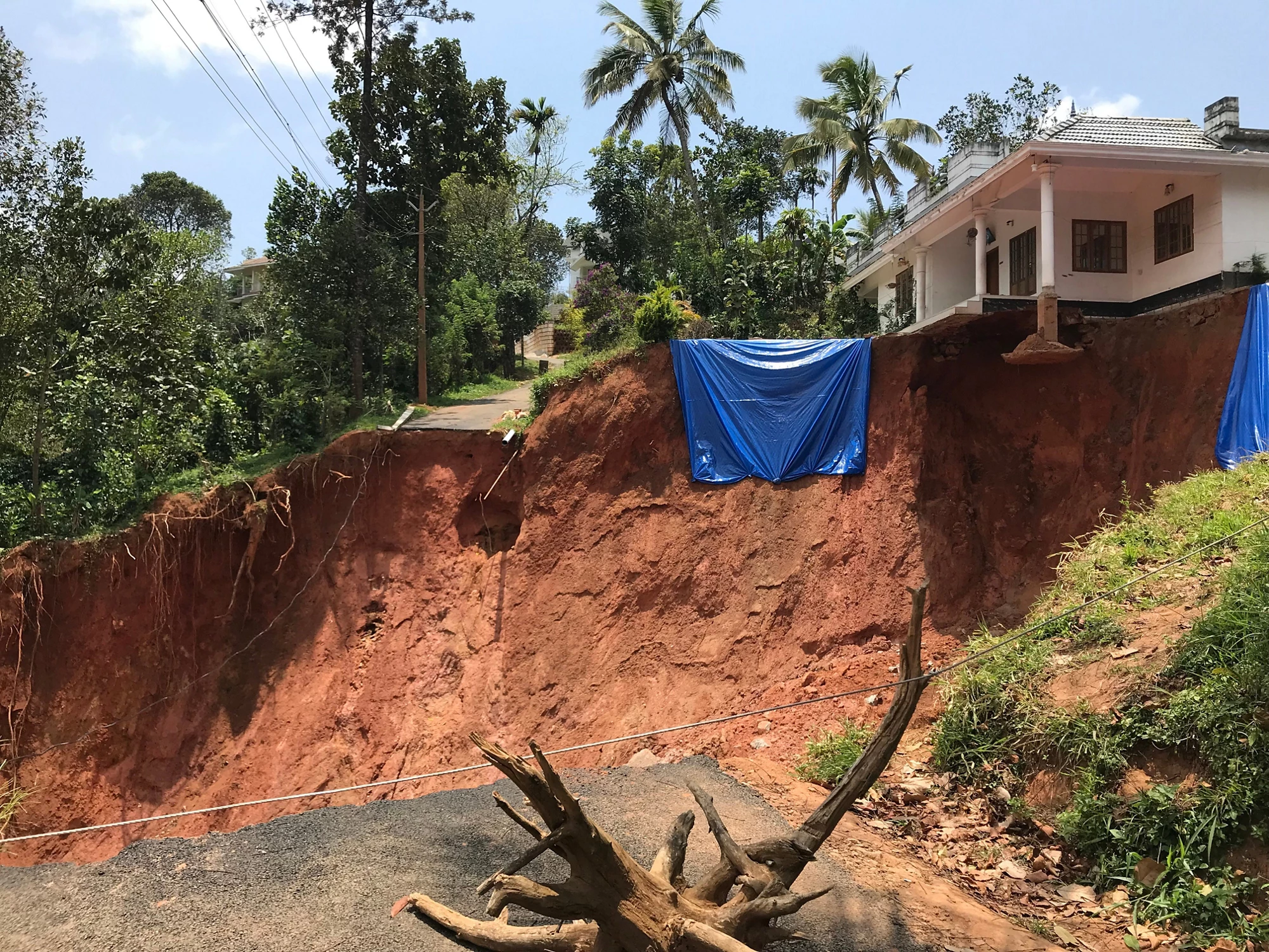
 A large landslide swept the foundation of a hill-top house at Idukki, Kerala. Photo Credit: Masatsugu Takamatsu
Imagine you live in a house with a beautiful view of downhill greens. One day after a storm you come out of the house and find the entire ground from the tip of your house is washed out for hundreds of meters. This is a real landslide that occurred in Kerala, India in August 2018.
5 million people in Kerala the most southwestern State of India, were affected by extreme and prolonged rainfall of August 2018. The monsoon caused widespread floods and more than 3,000 landslides across the state. Geohazards, particularly landslides, are a difficult natural hazard to manage. Unlike floods, landslides occur sporadically and are almost impossible to predict .
In addition, landslides disrupt lifeline infrastructure like roads and cost human lives by washing away houses and public buildings .
The seismically active Himalayan-Hindu Kush mountain belt with the world-most challenging terrain also affects other South Asian countries. Earthquakes, landslides, and heavy rainfall often cause long-term disruption of transport systems in the region, resulting in economic setbacks affecting internal trade and regional integration. Higher frequency of larger and intensified storms with changing climate will likely continue increasing the number of landslides in South Asia . Communities affected by landslides are often socially vulnerable to homelessness and, they rely on few roads for evacuation or for sourcing food and water.
Monsoons caused widespread floods and more than 3,000 landslides across the state of Kerala.
Workshops
In 2016, with the objective of empowering countries in South Asia Region (SAR) in building a resilient road transport network, the World Bank launched, with support from the Global Facility of Disaster Risk Reduction (GFDRR) and the European Union (EU), its Building Resilience to Landslides and Geo-hazard Risk in the South Asia Region program to support policy makers and technical agencies.
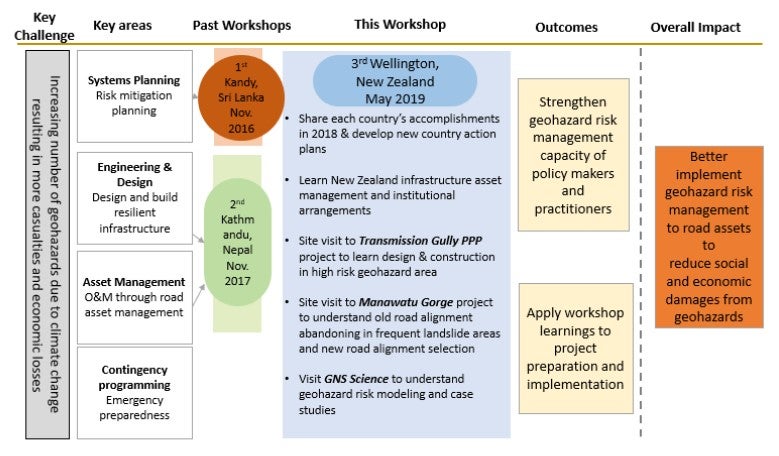
The South-to-South learning workshop series is one of the key vehicles employed in this program to provide South Asian countries with knowledge learning and experience sharing opportunities. The first event was launched in Colombo, Sri Lanka in 2016 with the second event in Kathmandu, Nepal in 2017. These workshops focused on geohazard risk management (GRM), including resilient road asset management and disaster preparedness to help strengthen the GRM capacity of policymakers and practitioners and support the development of country-specific action plans.
A third workshop was held in Wellington (2019) to explore New Zealand’s experience and advancement in building its geohazard-resilient infrastructure and asset management system. Thought-provoking discussions with experts and cross-country participants strengthened the participants’ skill base and knowledge on five core themes: institutional capacity and coordination, systems planning, engineering and design, asset management and contingency programming.

The theory of change, illustrated in the figure above, indicates how the workshop series can help South Asian countries strengthen GRM capacity and apply the lessons to their own projects and country-wide capacity building. In Afghanistan, for instance, the Ministry of Transport will apply the learnings of the workshop to support the selection of risk mitigation measures along the Salang Pass through the Bank-financed Trans-Hindukush Road Connectivity Project.
In Nepal, together with the Nepal Department of Roads (DOR), the Program hosted a slope protection design training to young road engineers and practitioners in Nepal and Bhutan so that they can assess, investigate and understand design measures for the road slope protection works. These are the good examples of how each country has moved forward to strengthen GRM following the action plans.
Geohazards are a difficult natural disaster to manage and yet the numbers continue to increase with climate change. Governments need to protect people and assets from the impact of these disasters.
Geohazards are a difficult natural disaster to manage and yet the numbers continue to increase with climate change.
Key takeaways to build geohazard resilience:
- Spatial risk quantification - High-resolution topographic data and up-to-date exposure datasets help risk assessment zoom into community-level or even house-level rather than broader district or town level. When you build a house, you want to understand hazard risks of the specific location, and the government needs to be able to judge if the area is suitable for building houses and what kind of building regulations have to be applied from a disaster risk perspective.
- Risk-informed planning - Risk information is useful for different sectors such as new roads or road widening planning in the road sector, land-use planning for urban and rural areas, or watershed management for erosion and sedimentation control . This requires close collaboration and sharing information between agencies and stakeholders across sectors.
- Impact-based early warning - Development of an effective early warning system is important to plan ahead how to swiftly evacuate people from high-risk areas through safe routes . Disaster Risk Management agencies need to closely collaborate and coordinate with HydroMet service agencies who predict and monitor inclement weather and flooding.
This GRM capacity building program is one small tool to help each government develop a comprehensive and robust geohazard risk management policy and technical framework to make a big impact on the safety of people from geohazards.
Video links:
New Zealand site visit: https://www.youtube.com/watch?v=_xKo-9ah6iI
Building resilient transport in South Asia: https://www.youtube.com/watch?v=hMM3CWG1qA0


Join the Conversation