“Air pollution is one of the biggest environmental threats to human health, alongside climate change”. This subtitle from a 2021 WHO article raises an alarming concern. In addition, 92 percent of pollution-related deaths occur in low- and middle-income countries, showing a deep inequality in the consequences of this problem.
If we want to be able to tackle this threat, we need good data to both quantify the extent of the problem and test the effectiveness of different solutions. Data on air pollution, especially in lower- and middle-income countries, where air pollution is highest, has traditionally been very limited. Generally, air quality data have been collected with high-resolution regulatory monitors, which are usually very costly and require intense maintenance. It is within this framework that the Development Impact Evaluation Department of the World Bank Group (DIME) and the Dakar Urban Transport Agency (CETUD) are collaborating with the Center for the Control of Air Quality of Senegal (CGQA) to pilot a data system to measure air pollution at a high-temporal and spatial resolution across the city of Dakar as a complement to the existing regulatory monitors managed by CGQA. Through a series of projects, the team is deploying an innovative network of low-cost sensors of the brands Purple Air (PA) and Atmotrack to capture the evolution of pollution in the city in relation to urban transport (image 1). These monitors measure both fine particles PM10 and PM2.5 at a fraction of the cost of regulatory monitors.
Image 1: Deployment of low-cost PurpleAir and Atmotrack monitors, as well as regulatory monitors across the Dakar Region
High-income cities, such as London or Oakland, have dense networks of air quality monitors that combine regulatory monitors with low-cost monitors. The benefit of high-quality data from this type of network could be especially impactful in rapidly growing cities in Africa where increased urbanization and investments in new infrastructure could have large impacts on air pollution. While a few regulatory-quality monitoring stations in a city can be helpful for measuring the overall pollution trends, they may not capture the large variation in pollution that can exist across areas and might mask important pollution inequalities across the city.
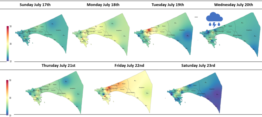
So, does pollution really vary that much? In short, yes! The data from over 25 Purple Air monitors across Dakar shows that pollution varies across space (different areas of the city) and time (different days and times of the day) (Image 2). Pollution levels are generally much lower on Saturdays and Sundays than on weekdays (for example, we measure a drop of 63% between Friday, July 22, and Saturday, July 23). Additionally, when it rains, the pollution level drops, demonstrating the important role that weather can play.
Image 2: Variation in pollution level captured by PurpleAir

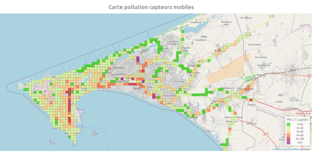
Additionally, within the implementation framework of the Plan for Urban Sustainable Mobility (PMUS) of Dakar-horizon 2035, Atmotrack air quality monitors were also installed on vehicles traveling around the city to help generate measures of pollution across the city. The temporal and spatial analyses realized show very high PM10 concentration levels along the most congested road segments. These results help to establish a correlation between traffic and pollution in Dakar (image 3).
Image 3: Levels of PM2.5 and PM10 captured by Atmotrack monitors on a vehicle
What are the policy issues?
The collection of air pollution data at a high temporal and spatial level of disaggregation is particularly important to conduct cost-benefit analyses of future projects and for helping decision-makers to better anticipate and quantify negative externalities. For example, CETUD conducted the pollution data collection on the road within the framework of a larger study on negative externalities of transport in Dakar that included, beyond air pollution, congestion, road crashes, and noise. By bringing together these different sources of data, we can learn even more about the impact of these negative externalities of transport on the population.
Case Study: Evolution of pollution in Dakar in response to COVID-19 policies
These types of pilot data systems make it possible to measure changes in air pollution due to specific policy changes, whether expected or unexpected. For example, as in many other countries, in March of 2020, the government instituted a curfew in Dakar to limit the spread of COVID-19. The data collected through the PurpleAir monitors demonstrated that pollution trends dropped immediately after this curfew policy (Image 4). In the months following the curfew policy, pollution gradually increased to its pre-Covid level. Similar approaches can be used to study the evolution of pollution in areas affected by other policies and projects such as the new Bus Rapid Transit.
Image 4: Level of PM2.5 concentrations before and after institution of COVID-19 curfew
Although this is exploratory work, it demonstrates the value of investing in air pollution data collection tools, as they help with monitoring the impacts of projects and policies in real-time. The Transforming Transportation Conference this week, which focused on “Accelerating Toward Green and Inclusive Mobility”, highlights the important role that transport plays in this space and data will be critical to track how we are doing in terms of achieving goals of green mobility. As we continue to measure pollution in Dakar, the work will help shed light on the potential impacts of the new transport investments once they are operational. Future updates on the evolution of pollution levels will be coming soon – stay tuned!
The project benefited from financial contributions from the European Union (EU), the United Kingdom Foreign, Commonwealth & Development Office (FCDO), and the World Bank’s Umbrella Facility for Impact Evaluation (i2i) through the ieConnect for Impact program.
The members of the team working on the impact evaluation study on pollution and having contributed significantly to the development of all material and the drafting of this blog are Sveta Milusheva, Marion Sagot, Mame Diarra Bousso Sarr, Ruiwen Zhang, and Aram Gassama from the World Bank, Bridget Hoffmann from the Inter-American Development Bank (IDB) and Amath Ndiaye, Ndeye Rokhaya Gueye and Khadim Cissé from the Executive Council for Sustainable Urban Transport (CETUD). The team benefitted from comments by Luc Lecuit, Mademba Ndiaye, Fatima Arroyo Arroyo, and Franck Taillandier. The team acknowledges the essential support of Aminata Diokhané and André Dioh from the Air Quality Management Center (CGQA).


Join the Conversation