 Kelani River in Sri Lanka
In the summer of 2016, floods and landslides caused by heavy rainfall wreaked havoc in Sri Lanka. One of the most heavily impacted areas was the flood-prone Kelani River basin, where flooding affected thousands of people and caused over $500 million in losses in the Greater Colombo area.
In the aftermath of the floods, the World Bank helped finance the Climate Resilience Multi-Phase Programmatic Approach Project, the first phase of which aims to improve flood resilience in the Kelani River basin and modernize disaster forecasting, preparedness, and warning systems.
A key element of this project is to construct a large, mechanical gated structure across the Kelani River—commonly referred to as a salinity barrier—to replace an existing static structure that partially blocks the river, exacerbating flooding nearby.
The salinity barrier will prevent saline water intruding into fresh river water during the dry season at a water treatment plant that supplies water for nearly 1 million people living in the capital city of Colombo and its suburb. During high-flow events, the gates of the new salinity barrier will open to transfer water flow downstream much more smoothly than the existing barrier.
While these barriers have been widely used in Sri Lanka, this new 110 meter-wide salinity barrier across the Kelani river will be one of the largest mechanically operated gated hydraulic structures in the country. Given this, the Ministry of Irrigation decided to conduct physical modeling to verify and optimize the detailed design before any construction began.
While we live in an age where AI can design or simulate pretty much anything in a virtual world, when it comes to hydraulic structures to control water flow such as weirs and dams, experiments using downscaled models of structures—commonly called physical modeling—is still used extensively and remains crucial for designing complex hydraulic structures. In the case of the Kelani river structure, physical modeling provides a better understanding of what the impact of the new barrier would be on sediment deposition and erosion patterns on the river bed and bank, and what additional protective measures against erosion would be needed.
With flood resilience top of mind in the design of the new structure, we brought engineers from the Ministry of Irrigation to Japan in the summer of 2023 so they could get firsthand experience on how large hydraulic structures are designed and tested using physical modeling practices. Complex hydraulic structures need high performance and reliability and many such structures have been built and safely operated in Japan for decades. The training was provided with financial support from the GFDRR Japan-World Bank Program for Mainstreaming Disaster Risk Management in Developing Countries and technical support from the GFDRR’s Disaster Risk Management (DRM) Hub in Tokyo.
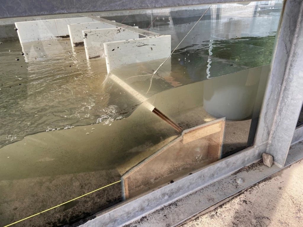
These engineers not only learned the theory behind physical modeling but were able to apply this to experiments using a four-feet wide channel with a scaled-down gated structure representing the new salinity barrier for the Kelani river. The team tested different scenarios of water levels and flow velocities to observe water flow and sedimentation patterns near the structure to see how design could be optimized.
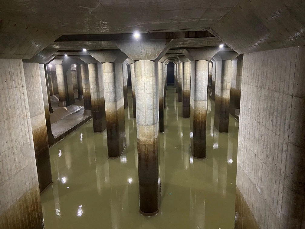
We also visited two large-scale urban flood-control facilities, designs of which were tested by physical modeling. The first was the Tsurumi river multi-purpose retarding basin in Yokohama, an 84-hectare open sports field that can hold up to 3.9 million cubic meters of water—enough to fill 1,500 Olympic-size swimming pools. Excess water from Tsurumi River is allowed to flow into this retarding basin, preventing the water from overflowing into the adjacent residential area and also protecting the megacity of Yokohama downstream of the river. The second was the 6.3 km underground Metropolitan Area Outer Discharge Channel in Tokyo, one of the largest of such structures in the world. The underground channel, with its massive concrete pillars (each weighing 500 tons to push down the structure against buoyancy) stores and channels floodwater from nearby low-lying flood-prone areas to the higher-capacity Edo River. Because of these massive pillars, the structure is often referred to as an “underground shrine”.
For hydraulic design engineers, there’s no better substitute than physical model experiments to optimize the design and build safe and resilient hydraulic infrastructure that many people will depend upon.


Join the Conversation