Working across borders to improve early warnings in South Eastern Europe

|

This page in:

Kalemegdan, Belgrade - Storm over Belgrade in 2012 – Source: Wikimedia Common

A massive storm system brought historic flooding across South Eastern Europe in 2014, causing more than $2 billion in damages in Bosnia and Herzegovina and shrinking Serbia’s economy by nearly a full percent. Two years later, in August 2016, thunderstorms in the Former Yugoslav Republic (FYR) of Macedonia dropped 93 liters of precipitation per square meter in just a few hours, sparking flash floods in the capital, Skopje, that killed at least 21 people.
 
In both cases, some of these impacts could have been reduced by improving cross-border monitoring and forecasting while strengthening early warning services at a national level. In FYR Macedonia, for example, even though the storm was being tracked by radar as it moved through neighboring countries, residents in Skopje were given very little time to prepare and there was insufficient local data to anticipate the storm’s potential impact in a timely manner.

Fortunately, governments are now working together to improve information exchanges across boundaries and strengthening regional early warning systems through the South-East European Multi-Hazard Early Warning Advisory System (SEE-MHEWS-A).
 
Initiated under the auspices of the World Meteorological Organization (WMO), with financial support from the United States Agency for International Development (USAID), this innovative, multi-country program is now being supported by both the World Bank and the Global Facility for Disaster Reduction and Recovery (GFDRR).


Sharing meteorological and, particularly, hydrological data between countries is often sensitive, owing to political tensions, competing economic opportunities associated with water resources and power generation, and legacy data policies. Despite these challenges, however, countries in the region have taken steps to share more real-time monitoring data for forecasting and early warning purposes. One example of this collaboration is the Flood Forecasting and Warning System in the Sava River Basin (Sava FFWS) initiative – designed to build on targeted data sharing between Bosnia and Herzegovina, Croatia, Montenegro, Serbia, and Slovenia financed by the European Union’s Western Balkans Investment Framework (WBIF) and implemented by the World Bank.
 
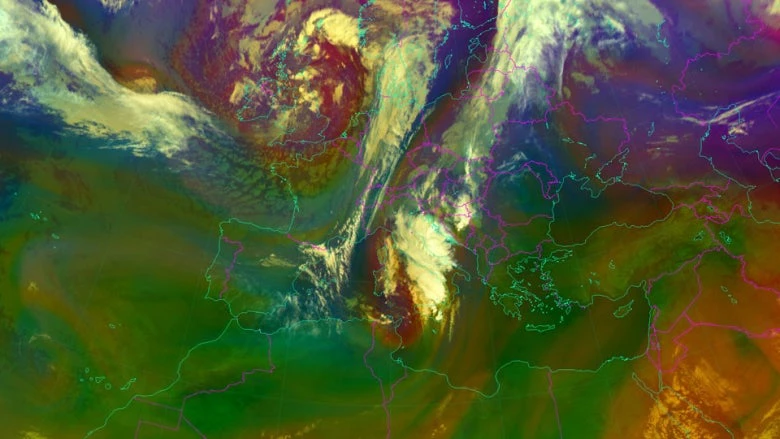
Generating weather forecasts involves assimilating data from national monitoring systems, satellites, and regional sources into numerical weather prediction models. Such computer programs simulate the physics of the atmosphere, helping forecasters understand what the weather might be in the next hours, days, and weeks. While extremely useful, running such models requires significant computing resources and technical expertise.
 
The SEE-MHEWS-A addresses these challenges by making outputs of existing models covering South Eastern Europe available to participating countries, so they do not need to run new models themselves.  In addition to being cost efficient, this consolidation of results will also create probabilistic information on potential weather conditions – giving forecasters a better understanding of future weather scenarios and related hydrological events to help improve local forecasts and enhance early warnings systems. Furthermore, because more national observations will be included, these models will perform even better in their local contexts.
 
Improved regional weather forecasting will help countries anticipate and prepare for intense rainfall, wind, hail, snow and extreme temperatures. The weather prediction models will also provide quantitative precipitation forecasts to better forecast floods. With probabilistic precipitation forecasts from the different weather models, hydrologists will be able to produce probabilistic flood forecasts, improving the quality of early flood warnings.
 

When large-scale weather patterns emerge, such as extratropical cyclones, different parameters of the earth's atmosphere need to be analyzed and closely monitored by decision-makers. On September 11, 2017, Northern Croatia was under the influence of severe thunderstorms, and extremely large amounts of precipitation were anticipated by meteorologists which caused flash floods and significant material damage in the cities of Zadar and Nin.  Source: EUMETSAT (2017)


All of this requires a well-coordinated, technical process driven by a spirit of transparent and open regional collaboration. While WMO is coordinating these effort, several regional European institutions have also indicated their intention to provide support – including  the European Center for Medium Range Weather Forecasts (ECMWF), the European Organization for the Exploitation of Meteorological Satellites (EUMETSAT), and European Commission’s Joint Research Centre (JRC). Several national hydrometeorological agencies in the region and beyond have also volunteered to develop and operate aspects of the system.
 
This collaboration transforms SEE-MHEWS-A into a virtual ‘system of systems’ - with various nodes providing computing and other services and products for the region. This spirit of technical cooperation also maintains respect for sovereignty, with only the countries themselves responsible for providing early warning services to their citizens. That is exactly why the term “advisory” is part the projects name: it does not deliver early warnings, but rather provides enhanced technical information for disaster risk management experts to support decision-making at the national and local levels.
 
Hopefully, this innovative partnership will not only make the communities of South Eastern Europe safer from extreme weather, but also will provide a solution-oriented model for future collaborative efforts on reducing climate and disaster risk in the region and beyond.

Authors

Daniel Kull

Senior Disaster Risk Management Specialist

Michael Staudinger

Director General of Austria’s Central Institution for Meteorology and Geodynamics (ZAMG) and Permanent Representative of Austria at the World Meterological Organisation

Felix Bongjoh
October 14, 2018

A well-conceived scheme of support to policy-oriented actions. Providing a solid framework for the sharing of meteorological information is an important step. Projects of this nature should strive for far-reaching results in terms of long-term actions that could mitigate weather hazards over long periods of time. Perhaps long-term schemes based on the probability of the future occurence of storms over periods of 5 to 10 years and even more could help goverments to mitigate some or most of it effects. The re-occurrence of storms leaving governments always embarrassed by untold amounts of destruction (loss of poverty, deaths) seems to be a fact to live with, as it could be argued that without an elaborate scheme of the nature provided by the project, matters could be worse - in fact disastrous.
Could meteorological schemes be more proactive in terms of making bold concrete recommendations for actions aimed at establishing physical environments along coastlines that could further mitigate the damage caused by storms in the long term? Perhaps time-series studies on the behavior of natural phenomena and patterns that lead to weather hazards could go a long way to influence respective policy measures on dealing with more effectively with storms and their consequences. In this regard, schemes should be worked out to foster collaboration between environmentalists and meterologists within a framework much broader than what currently exists so that governments are not always placed in the precarious situation of dealing with storms on a relatively short-term basis as they occur within the predictable limits of forecasts. Longer-term meteorological patterns as such could enable governments to come up with long-term policy measures and strategies to cope more effectively with weather hazards.
Of course, the proposed approach of forging a closer link between environmental and meteorological factors would be achieved at a greater financial cost. It would be up to experts to weigh in on how cost-effective strategies could result in more realistic interventions.
Although the project in question deals with Europe, we do not have to go far to learn from similar hazards in the US that have occurred one after the other within a short period, each time taking a significant toll on lives, property and the environment. This corroborates the need to come up with more radical meteorological schemes anchored on sound environmental practices as the basis for informing policy and decision-making with a view to long-term solutions.
In this regards, the continuous evaluation of projects as they are implemented could be helpful. More frequent and ad hoc regional meetings could also be source of invaluable inputs for ongoing projects. Data banks should be enriched, more widely disseminated and accessed by various actors at both regional and country levels. More extensive monitoring and communication schemes should accompany measures recommended to strengthen respective government policy guidelines.

Daniel Kull
October 16, 2018

We fully agree that weather- and climate-related risks need to be understood and managed with a long-term perspective. We aim to support “seamless prediction” (see link below) across timescales, ensuring that actionable information and early warnings are available from the short-term for extreme weather (hours to days to weeks), to the medium-term for seasonal issues (months to years), and to the long-term for climate change (years to tens of years). Decision-makers can then plan and act accordingly, whether it is for the next local storm, regional flood, El Niño or long-term climate impacts. We also support a range of disaster and climate risk management approaches that utilize this information, as reviewed in Building Resilience: World Bank Group Experience in Climate and Disaster Resilience (see link below).
We also agree that hydrometeorological information is not sufficient on its own, needing to be combined with socioeconomic and environmental information to truly provide decision-making and planning guidance. This is called “impact-based forecasting” and requires cross-discipline collaboration and information sharing. Providers and users of climate and hydrometeorological information services need to work together to ensure that what is produced meets public and commercial needs, across all economic sectors. Inclusive stakeholder dialogue and agreements are needed to enable user-centric information services, such as a National Framework for Climate Services, for example what we are supporting in Moldova.
As we have seen in Central Asia, only by strengthening activities across the weather information value chain (observation, modeling, forecasting and service delivery) can we ensure that communities and countries become more disaster and climate resilient (see link below).
Links:
Explanation of seamless prediction: https://public.wmo.int/en/media/news/seamless-prediction-from-minutes-m…
Building Resilience - World Bank Group Experience in Climate and Disaster Resilience: https://openknowledge.worldbank.org/handle/10986/16639
Moldova National Framework for Climate Services: https://www.gfdrr.org/en/publication/nfcs-moldova
Central Asia Hydrometerology Modernization Project: https://youtu.be/vtJFlzgNWXg

Felix Bongjoh
October 15, 2018

(continued from previous comments).
In addition to the measures given above, the intervention's sustainability in the longer term would depend on how well equipped governments are to tap into work done with the assistance of the WB. This preparedness can be achieved revamping curricula in respective education and training systems, especially in the fields of meteorology and environmental management , but also in such fields as architecture, urban planning and development. To the extent that infrastructure and indusrty could also contribute to the degradation and pollution of the environment, thereby causing paterns of climate change and irregular weather hazards (including hurricanes, mudslides and earthquakes), curricular reforms would also be useful.
The health sector is also vulnerable to natural catastrophes, especially when safe drinking water is contaminated. Poor living conditions due to the overcrowding of inernally displaced persons may cause outbreaks of diseases attributable to poor hygienic conditions. A comprehensive approach to early warning systems should therefore involve actors from the aforementioned sectors and have implications for continuous improvements in terms of curricular reforms with far-reaching on in-service training in all spheres of socio-economic activity, including experts routinely mobilized to assist internally displaced persons.