The availability of disaster risk information is particularly important for a fragile state like Afghanistan where 4 out of 5 people rely on natural resources for their livelihoods. [2] To strengthen resilience, investments in Afghanistan need to incorporate information on natural hazards in their planning, design and implementation. To help support government efforts, the World Bank and the Global Facility for Disaster Reduction and Recovery (GFDRR), in close cooperation with the Afghanistan National Disaster Management Authority (ANDMA), recently produced a comprehensive multi-hazard assessment level and risk profile [3], documenting information on current and future risk from fluvial and flash floods, droughts, landslides, snow avalanches and seismic hazards. The main findings, methodology and expected outcomes were recently discussed and presented to the Disaster Risk Management community of practice within the World Bank Group. A number of takeaways from the discussion are presented below:
What is Afghanistan’s risk profile and vulnerability?
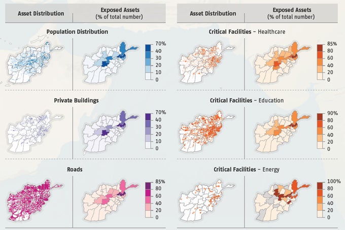
- Flooding is the most frequent natural hazard historically, causing average annual damage estimated at $54 million; large flood episodes can cause over $500 million in damage
- Historically, earthquakes have caused the most fatalities, killing more than 10,000 people since 1980
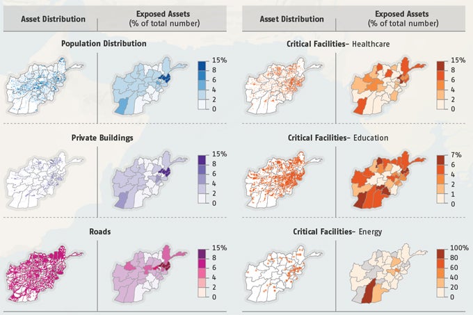
- 3 million people are at risk from very high or high landslide hazard
- Droughts have affected 6.5 million people since 2000; an extreme drought could cause an estimated $3 billion in agricultural losses, and lead to severe food shortages across the country;
- An estimated 10,000 km of roads (15 percent of all roads) are exposed to avalanches, including key transport routes like the Salang Pass


- Retrofitting schools throughout Afghanistan to be earthquake resistant would reduce potential economic losses by 60 percent and reduce fatalities by 90 percent
- It is more cost-effective to build new earthquake-resistant roads and to keep money in reserve for damage repairs than to retrofit or reconstruct existing roads
- Strengthening dikes upstream and retrofitting homes would improve flood protection in cities; one new embankment in Kabul could save $600,000 in flood damage
- Diversifying livelihoods, and improving the effectiveness of agricultural practices, such as by using crops and irrigation methods that reduce water wastage, could increase agricultural productivity, reducing the reliance on water availability
- Retention structures, including concrete galleries over roads and early warning systems, can be effective in reducing avalanche risk
Afghanistan presented a number of specific challenges in terms of collecting data. First, a lack of national security restricted the ability of the Bank team to undertake structured fieldwork and validate data points. This would have been particularly useful for analyzing different geographic locations vulnerable to flooding or landslides, for instance, since Afghanistan’s complex topography may imply variation in regional trends. Here, the development of the risk profiles largely depended on information provided by in-country Government counterparts, development partners and Bank colleagues, alongside satellite observation and global modelling tools. Similarly, in a fragile state like Afghanistan, making use of the territorial knowledge and data provided by NATO’s International Security Assistance Force (ISAF) was also instrumental. An example of how various data sources were integrated was the nationwide avalanche modelling: local snow observations and high-resolution elevation data were made to construct the model, while global rainfall datasets were needed to apply the model on a country-wide basis.
How is this information useful for the Government in advancing its resilience agenda?
ANDMA has limited capacity at the central level, even more so at subnational level. Previous donor-supported programs have generally been fragmented, at small scale and have focused on post-disaster response rather than on disaster prevention and planning. An important element for the Government has been the recognition that disaster risk information provides an opportunity for cross-sector collaboration and can facilitate mainstreaming DRM in investments related to transportation infrastructure, energy investments, housing and social infrastructure, to ensure a more resilient future for Afghanistan. Finally, while the Government already has a lot on its hands, this tool could help to prioritize investments where vulnerability is highest and needs are greatest.
Related:
Website: www.worldbank.org/resilientafghanistan
Video: http://www.worldbank.org/en/news/video/2017/03/29/afghanistan-disaster-risk-management-program
GeoNode: http://disasterrisk.af.geonode.org/


Join the Conversation