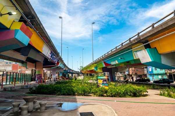
 Espacio público debajo de la autopista
When you walk around your city, do you feel that some areas are warmer than others?
It may be more than just a feeling, as growth patterns in cities are impacting temperatures. The average annual air temperature in a city with a million and a half or more people can be between 1 °C and 3 °C higher during the day compared to its surrounding area, while at night that difference can reach up to 10 °C.
In Latin America, for example, the process of unplanned urban expansion has been accompanied by drastic changes in land use, replacing the original vegetation layer with asphalt materials that are waterproof and absorb solar radiation.
Additionally, the growing number of cars has generated an increase in anthropogenic or residual heat emissions and air pollutants, which get trapped in the densest urban areas due to the concentration of buildings.
These conditions give rise to a phenomenon known as urban heat islands, which have negative consequences on people’s lives and the environment. Among the key impacts we can highlight higher energy consumption due to an increase in energy demand for cooling purposes; ramifications on human health including respiratory problems, dehydration, and even higher mortality rates due to heatstroke; and greater atmospheric contamination due to worse air quality.
This phenomenon disproportionately affects the most vulnerable neighborhoods, which often grow without planning, lack green areas, and are characterized by poor housing conditions. Thus, understanding urban heat islands and their impacts is key to reversing the situation and planning more sustainable and equitable cities.
The experience in Buenos Aires
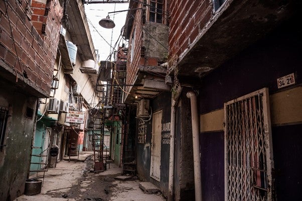
In 2017 we started accompanying the Government of the City of Buenos Aires’ Social and Urban Integration Program of Barrio Mugica neighborhood (formerly Villa 31), in the city center. Barrio Mugica is one of the densest areas of the city, and on average people live in spaces of 42 m2 and access less than 1.6 m2 of public space per person, when the average in the city is 6 m2.
Shortly after The World Bank began working there, we started to hear people say that the temperature in the neighborhood was higher than in the rest of the city. During summer months we began to feel it. However, there was no data available to understand the dynamic.
Barrio Mugica urban heat island study
With the support of the Energy Sector Management Assistance Program (ESMAP), The World Bank worked together with the Special Projects Unit of the Padre Carlos Mugica neighborhood (former Secretary of Social and Urban Integration) on a study to analyze the urban heat island of Barrio Mugica.
Mobile thermometers and a weather station were installed in the neighborhood to collect temperature data on different days and periods of the year. In addition, satellite images were processed to understand the progress in the sealing of soil in the last three decades.
Results indicated that the neighborhood is indeed one of the hottest spots in Buenos Aires. In the summer, the temperature in the downtown area and in certain areas of the Barrio Mugica is 3 °C higher than in Aeroparque, the nearby airport. Within the neighborhood, a thermal amplitude of up to 6 °C was recorded between places with high sun exposure and areas with zero insolation, such as the narrowest streets.
This data enabled us to identify measures to reduce the observed heat effects and inform the program. Some of the measures identified included the need to increase the tree surface and generate designs with deciduous vegetation (which lose their leaves in autumn) on the exposed areas to reduce the hot spots in summer and allow adequate insolation in winter.
Considering these aspects, the Special Projects Unit is finalizing the construction of a new public space under the Illia Highway, formerly the site of informal housing. The 23,000 m2 public park will increase public space per inhabitant by 36%. Additionally, the government is implementing an urban greening plan, and has already planted more than 1,300 trees.
Taking into account these and other public space works, the Mugica neighborhood has now more than 7,400 m2 of new green areas, which are essential to reduce the urban heat island effect. Furthermore, as part of the program, new housing was built with passive design measures, such as cross ventilation and reflective roofs. Passive design aims to achieve thermal comfort using natural resources through measures such as building orientation, air sealing, continuous insulation and windows and daylighting.
This example proves that sometimes simple measures such as collecting temperature data and studying its evolution can have a great impact on improving the quality of life in cities, particularly for the most vulnerable.
The Guide for Space Cooling published by the World Bank, provides more information regarding measures to help initiate and advance sustainable space cooling initiatives.
Testimonies from neighbors (only available in Spanish).
Photos of Public Space under the Illia Highway:
Before

After

Before
After
Before

After


Join the Conversation