 Aerial view showing urbanization on Luzon island, Philippines. (Photo: CherylRamalho / Shutterstock)
Because national definitions of urban and rural areas differ significantly from one country to another, it is difficult to compare these areas across national borders. If we can’t compare the performance of urban or rural areas across national borders, then we can’t learn from policies used in other countries. It also means we cannot meaningfully compare the United Nations (UN) Sustainable Development Goals' (SDGs) indicators for urban and rural areas across countries.
To facilitate international comparisons, a coalition of six international organizations developed a new global definition of cities, towns and semi-dense areas, and rural areas. On March 5th, the UN Statistical Commission endorsed the Degree of Urbanization as a recommended method for international comparisons.
Many countries use a minimum population size to define an urban area, but that size can be 200 (as in Denmark), 2,000 (Argentina), 5,000 (India) or 50,000 (Japan) or even 100,000 (China). Some countries don’t use a statistical definition but designate urban areas by administrative decision. In other countries, the sectoral employment or provision of infrastructure and services is used to determine whether settlements should be classified as urban or rural.
Finally, once categorized as urban or rural, places are rarely recategorized. Some of this resistance may come from the allocation of fiscal transfers – consider India, where getting reclassified as urban may cause places to lose government transfers, or Egypt, where getting reclassified as urban would trigger additional public investment for higher-level service delivery requirements, including police stations and courthouses.
A wide-angle view to measure urbanization
We decided to take a wide-angle view to facilitate comparability across countries. By introducing an objective and data-driven approach to measuring poverty and applying this approach globally , the Degree of Urbanization seeks to do for the definition of urban what the $1/day poverty line did for poverty measurement in the 1990s.
The Degree of Urbanization identifies three types of settlements:
- Cities, which have a population of at least 50,000 inhabitants in contiguous dense grid cells (>1,500 inhabitants per km2);
- Towns and semi-dense areas, which have a population of at least 5,000 inhabitants in contiguous grid cells with a density of at least 300 inhabitants per km2; and
- Rural areas, which consist mostly of low-density grid cells (<300 inhabitants per km2).
Advantages of the Degree of Urbanization approach
This new approach offers several advantages:
- Simplicity and transparency. It relies on the simple combination of population size and density applied to the population grid, instead of a multitude of criteria or complex and lengthy calculations. An increasing number of countries have their own population grid. Several global population grids have been estimated and are available for free, including the Global Human Settlement Layer Population Grid (GHS-POP). The estimated Degree of Urbanization for each country in the world using GHS-POP can be found here.
- Driven by population size and density. Population size is used by more than half of the national definitions of urban and rural areas. The thresholds used in the Degree of Urbanization take inspiration from these national definitions. However, it uses two thresholds instead of one. For cities, it uses 50,000 inhabitants as Japan does. For towns and semi-dense areas, it uses 5,000. Out of the 100 countries that use population size threshold, 85 use the 5,000 threshold or a lower threshold. The thresholds used in the Degree of Urbanization were also tested to ensure that they produce a valid and robust classification and a balanced population distribution across the three classes.
- It helps monitor progress on the SDGs. The SDGs include a multitude of indicators that should be collected for cities, urban, and rural areas, including access to electricity, water, the Internet, and all-weather roads. Some definitions of urban areas, however, include access to water and electricity. This makes it impossible to monitor these services in urban areas because it becomes a circular argument. All urban areas have water because by definition they can only be urban if they have access to water. For example, the definitions used by Bangladesh, Cuba, and Panama all include access to drinking water. Because the Degree of Urbanization does not include services or infrastructure, it can monitor these services in an unbiased manner.
- It captures agglomeration economies. Because the definition relies on the spatial concentration of the population, it captures the logic of agglomeration economies. The cost of service provision tends to increase from cities to towns and semi-dense areas and then to rural areas. As a result, access to these services tends to be highest in cities and lowest in rural areas. For example, access to the Internet and having a bank account both follow a clear urban gradient in all four country income groups (Figure 1 and Figure 2).

- Cost-effective monitoring. The Degree of Urbanization can be used to re-aggregate existing data. For example, if a statistical office has measured local employment rates, then it can calculate employment rates by Degree of Urbanization. Geo-coded micro data can also be aggregated. This was done for the Gallup World Poll in 115 countries and for the Demographic and Health Survey in 41 countries in a new report by Vernon Henderson et al. This allowed us to show that access to safely managed drinking water is higher in cities, second highest in towns and semi-dense areas, and lowest in rural areas (Figure 3) in almost all of the countries covered by this survey.

Comparing the Degree of Urbanization with other approaches
As with any newly proposed method, it raises questions, and people want to know how it compares to existing methods. The main questions raised by national statistical offices and academics are addressed below.
Is the estimated rural population too low?
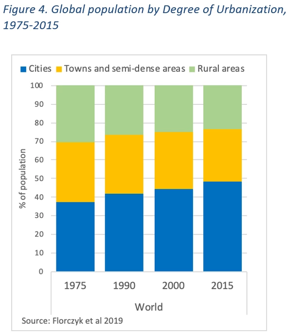
Applying the Degree of Urbanization to the global population grid GHS-POP results in an estimated rural population share in 2015 of 24%, which is considerably lower than the 46% based on national definitions (Figure 4).
The main cause for this difference is that 12 large countries classify towns as rural areas. China and India account for half of the difference in rural population. China’s definition makes it explicit that towns and small cities are not considered urban, because they use a threshold of 100,000 inhabitants for urban areas. India uses a threshold of 5,000 inhabitants but combines it with other criteria, which leads to most towns being classified as rural. A further 10 countries account for 30% of this difference: Bangladesh, Democratic Republic of the Congo, Egypt, Ethiopia, Indonesia, Nigeria, Pakistan, Sudan, Uganda, and Vietnam. In short, 12 countries account for three-quarters of the difference between the rural population shares.
In some countries, population data with a high spatial resolution was not available. Applying this method to a grid based on more precise data may lead to higher rural population shares.
Should a definition of urban and rural areas include agriculture employment?
Thirty-seven countries have a national urban area definition, which includes a maximum share of employment in agriculture. These countries are primarily located in Africa and Asia. The employment share in agriculture, however, differs substantially between countries and by level of development. In high-income countries, it is 3% compared to 63% in low-income countries (Figure 5). Including such a criterion in a global definition would lead to entire countries becoming rural or urban, which would be an obstacle to comparisons. Furthermore, this share is dropping quickly. In 2000, 40% of global employment was in agriculture. In 2018, it had dropped to 28%. As a result, including this criterion would also reduce the comparability over time.

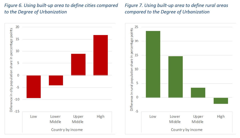
Should a definition of urban and rural areas be based exclusively on built-up areas?
Historically, the data on buildings had a higher spatial resolution than data on people. As a result, definitions used buildings as a proxy for the spatial concentration of population. For example, several Nordic countries define a settlement as buildings less than 200 meters apart. Several academics also use buildings or built-up area – see, for example, the Urban Extent used by Shlomo Angel, Africapolis and the building density method developed by Marie-Pierre de Bellefon et al. 2019. With the improvements of population data, however, this indirect approach is no longer necessary.
Furthermore, the amount of built-up area per capita is closely linked to the income of a country and will distort the population share in cities and rural areas. To show this, we defined cities as cells of 250 by 250 meters that are at least 50% built-up and rural areas as cells that are less than 25% built-up. These thresholds are used in several built-up area definitions of urban and rural areas.
Compared to the Degree of Urbanization, cities defined by built-up area alone have a population share that is 17 percentage points higher in high-income countries and 9 percentage points lower in low-income countries (Figure 6). For rural areas, using built-up area increases the rural population share by 24 percentage points in low-income countries (Figure 7) and reduces it by 2 percentage points in high-income countries. This makes built-up-area-based definitions of urban and rural areas less suitable for international comparisons.
Should a definition of urban and rural areas rely on relative thresholds, not absolute ones?
Some academics have argued in favor of using relative thresholds to define urban and rural areas. This could mean, for example, identifying the 10 most urbanized areas in a country. However, a global definition should ensure a high level of comparability across both space and time. Comparing the 10 most urbanized areas in one country with the 10 most urbanized in another does not ensure that these areas have the same level of urbanization. The level of urbanization in the globe is increasing, but a relative threshold cannot capture that, either. Therefore, relative thresholds do not allow for good comparability across space and time.
Conclusion
The Degree of Urbanization method classifies cities, towns and semi-dense areas, and rural areas in a simple and transparent manner. By standardizing the classification approach and applying it at the global level, it can help identify and measure the effectiveness of the policies in different countries that improve the quality of life in these areas. It will also help monitor access to services and infrastructure and other SDG indicators in a way that enables meaningful comparison and aggregation. This method will be further tested and implemented in many countries around the globe.


Join the Conversation