Challenges to implementing urban master plans – what are we missing?

|

This page in:

Aerial View of Tanzania (Photo by Chyi-Yun Huang)
We often hear statements saying that many Sub-Saharan African cities are 60-80%  “unplanned.” However, this seems quite contradictory because many of the larger cities, in fact, have some form of a master plan. Why do cities with master plans appear so unplanned and unstructured today? What needs to change in order to improve the planning process and better manage urban growth moving forward?


To shed light on these questions, we attempted to investigate the impact and effectiveness of urban planning on city spatial development in seven Tanzania secondary cities using a variety of spatial analytical tools and satellite and remote sensing imagery.
 
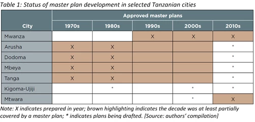
We observed that early master plans are somewhat successful in providing broad guidance on each city’s population projections and main structural forms. However, they were implemented only to a limited extent or proved rather ineffective in concretely guiding development, especially in terms of major land uses and supporting infrastructure and facilities.
 
For example, we assessed the degree to which various types of land uses align with previous master plans, in the city center versus peri-urban areas. Interestingly, we found that overall, the levels of land use conformity to historic master plans are low (less than 50%). In city centers, these are consistently around 35%-45%, while that in peri-urban areas varied significantly (see Figure 1, 2 and 3).
 
Further, cities with master plans existing from earlier decades did not show better conformity compared to cities that adopted master plans later; over time, this conformity did not change or improve significantly either. However, notably, residential conformity in core urban areas is generally high (ranging from around 48 percent to 78 percent conformity), while economic uses (commercial and industrial areas) have relatively lower levels of conformity—averaging around 17 percent and 25 percent, respectively.
 
Figure 1: EO4SD-urban (GAF for ESA/World Bank, 2018) World Bank and Ardhi team interpreted land cover using open satellite data and Local Government Revenue Collection Information System
Figure 2: EO4SD-urban (GAF for ESA/World Bank, 2018)
Source: Compiled from EO4SD operations report (for this study)
Source: World Bank analysis based on satellite imagery and land use classification from EO4SD-urban (GAF for ESA/World Bank, 2018)
Interestingly, a sample of detailed area or neighborhood-level plans were found to be more effective in guiding development (demonstrating 50%-94% land use conformity to detailed plans), although their coverage is generally low (only small areas of the city have detailed plans). This apparent higher conformity to the Detailed Planning Scheme (DPS) could be attributed mainly to its inherent affiliation with the formal planning process (the adoption of a DPS classifies an area as planned) and/or the less developed or orderly nature of the areas selected for detailed planning. However, it also suggests that the more detailed and granular the guidance, the better it will be for municipalities to better enforce actions against non-conforming development.
 
We further observed that many of our case cities faced increased fragmentation and dispersion, with the urban expansion process strongly aligned with development of major roads, forming ribbon developments or leapfrogged islands. This is especially pronounced in peri-urban areas. Further, these cities all have sizeable unplanned settlement areas and continue to experience significant expansion (from around 20%-30% growth) with little conversion into planned settlements.
 
Source: World Bank analysis based on satellite imagery and land use classification from EO4SD-urban (GAF for ESA/World Bank, 2018)
Why were early master plans rather ineffective at guiding development then? As it turns out, Tanzania’s present-day urban form is largely the product of growth in the absence of implementation tools and enforcement mechanisms over decades. Our findings assert that the critical reasons for the ineffectiveness of master plans in the cities studied are:
  1. Inherent weaknesses in the master plans themselves;
  2. Disconnect between spatial planning, sector or infrastructure plans and budgeting and investment planning decisions;
  3. The lack of coordination among key agencies;
  4. Lack of or ineffective development controls;
  5. Unrealistic planning standards and regulations; and
  6. Limited capacity and resources for enforcement;
 
Solutions and approaches to planning therefore need to be innovative but also practical. Also, more can be done to empower local authorities as they have the keenest on-the-ground knowledge. What do you think could help to improve the effectiveness of master plans in your city?
 
Find our full report here: Translating Plans to Development: Impact and Effectiveness of Urban Planning in Tanzania Secondary Cities.

Acknowledgment note: Support to this study was provided by GAF under the European Space Agency (ESA)’s Earth Observation for Sustainable Development (EO4SD) initiative’s dedicated activity cluster on urban development.

Related links:


Authors

Chyi-Yun Huang

Senior Urban Development and Disaster Risk Management Specialist

Joseph Walter Pade
February 27, 2019

The element of people centred planning is also very critical, some of these plans fail because the planners usually want to plan for the people rather than planning with the people, proposals usually dictated and certainly the challenge of resources occasioned by ever reducing Own Source Revenue generation in these Cities among other factors.

Chyi-Yun
February 27, 2019

Hi Joseph,
I think you are absolutely right about the importance of people-centered planning, and hence it is critical to have a participatory process during the drafting of plans. Resource and staffing challenges are very real too, and often what we hear from planners or authorities. However, we wanted to highlight there are other issues and reasons beyond resource constraints which could possibly be addressed.

Celine D’Cruz
February 27, 2019

When trying to find land in the city of Mumbai for the poorest of the poor, the pavement dwellers we looked at the Master Plan to check for possible available lands. We noticed that a piece of land reserved for low cost housing was occupied by a cigarette factory. That is when the penny dropped and the communities realized that just like the powers that be change the rules of the Master plan they, if organized could use the Master Plan and its reservations to their advantage.

liz palmer
March 03, 2019

This is fascinating research. Have you done the same to assess the community-level impact of different planning strategies in refugee camps?
Also, is there similar research being done on the impact of Word Bank projects?

Dan
March 08, 2019

Very interesting study. I was wondering how this data might correlate to the cost of doing business in these locales as well as to rates of transparency/corruption. Would the deviation to the master plan - particularly for non-residential uses - stem from a rational decision to avoid costs, whether legally prescribed or not?

Boaz Mwubahiman
July 24, 2020

This research came into existence and indeed, i think the gap is still there especially through local base implementation of master plans even Companies that develope master plans from most of African countries are not contextually local situation and don’t provide detailed plans,