 A group of Freetown residents pose with their seedlings.
Freetown, located at the seaward tip of a heavily forested, mountainous peninsula, is the capital of Sierra Leone, dominating its urban, economic, and social landscape. Each year, more than 100,000 people in search of employment move to the city, and the urban fringes continue to push deeper into the steep forest expanses outside the city. As a result, an equivalent of 12% of total canopy in the area was lost per year between 2011 and 2018.
Loss of tree canopy directly affects catchment areas for water reserves, exacerbating the risks of landslides, flooding, and coastal erosion. Loss of tree and vegetation cover also threatens biodiversity. Against the backdrop of population expansion and rapid urbanization, the Freetown City Council came up with a plan to plant and grow 1 million trees by 2022—an effort that would increase the city's vegetation cover by 50%.
Welcome to #FreetowntheTreeTown—an unconventional tree-planting campaign. This innovative effort harnesses digital and disruptive technology to create employment opportunities for local youth during the COVID-19 pandemic; it also helps establish long-term climate resilience for the community. The campaign comes with ecosystem benefits that include reducing heat stress, improving air and water quality, and reducing flooding and landslide risks.
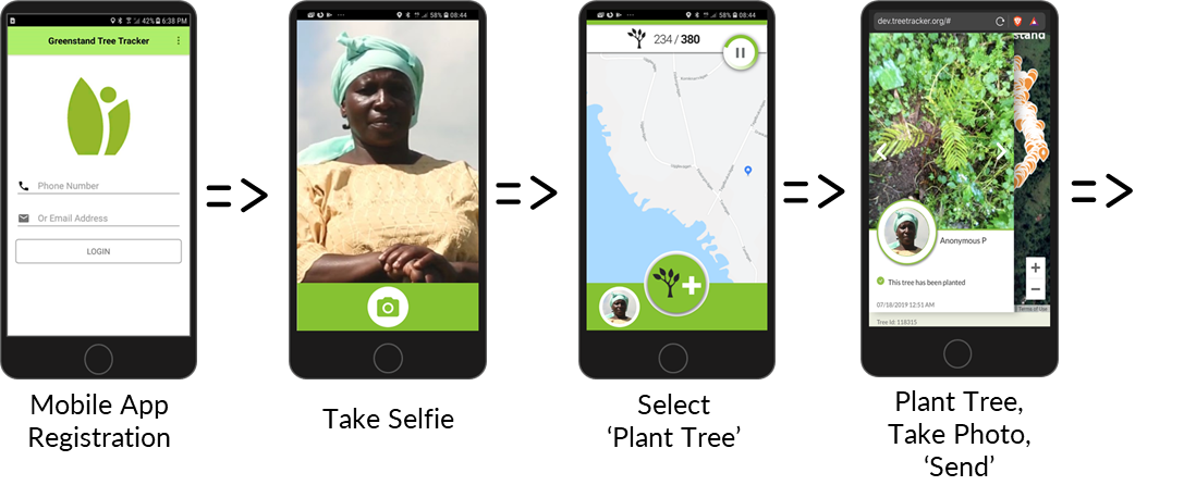
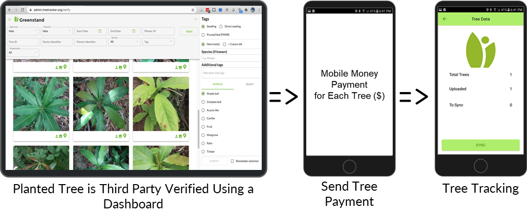
The campaign pioneers an innovative, sustainable tree-growing model. Freetown City Council, working closely with neighboring Western Area Rural District Council, partnered with Greenstand, a nonprofit that develops open-source technology to manage environmental goods and services. Community-based growers use its TreeTracker app on locally available smartphones to create a unique geotagged record, or ID, for each new tree planted—including a photo. Growers revisit each seedling periodically, to water and maintain, verify and document the plant's survival—and receive mobile money micropayments for their efforts. The goal of this growing and monitoring model is to enhance community ownership over the entire tree-growing project chain—a measure to ensure that the targeted 80% tree-survival rate is achieved.
Beyond the individual geotagging of new plantings, the growing model also includes an intricate seedling-purchasing, distribution, and management system supported by open source applications. These include the Open Data Kit for operational surveys, QGIS for geospatial data management and analysis, and third-party verification systems to ensure transparency for seedling-growth validation over time.
To ensure sustained financing for tree growth, tree IDs can be turned into “impact tokens,” which can be bought, sold, and traded by businesses and individuals. This approach will generate a new revenue stream to fund more tree-planting and growing support.


In the initial, 2020-21 phase, planters successfully planted and tracked 250,000 trees during the rainy season, focusing on higher slope areas where communities are susceptible to landslide risks. Together with 10 commercial tree nurseries and 10 community-based organizations, the project has created more than 550 short-term jobs, especially for marginalized, vulnerable, and underemployed women and youth. An additional 50,000 mangrove trees will be planted to restore damaged coastal wetlands and to cap off an incredibility successful inaugural phase. The project has also sold its first 5,000 tree “impact tokens,” and the revenue will provide financing to plant and grow an additional 5,000 trees during the next phase.
The second phase of this effort to build a climate-ready city will continue to endorse community engagement, participation, and impact. Another 700,000 trees will be planted during the 2021 and 2022 rainy seasons. These trees will be cultivated along major and secondary roads, around key water sources and other critical infrastructure, and within communities, neighborhoods, and public spaces.
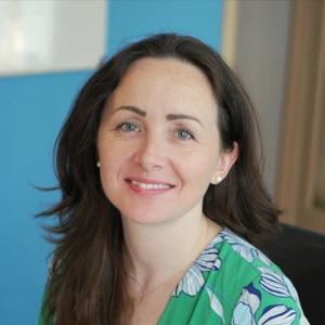
The campaign is part of the city’s ambitious three-year Transform Freetown Strategy for 2019–2022. The strategy is aimed at reshaping the capital into a productive, livable, and resilient city by improving urban governance, investing in resilient infrastructure, and promoting urban greening. These activities are also contributing to Sierra Leone’s Medium-Term National Development Plan 2019–2023, especially policy cluster seven: addressing vulnerability and building resilience. Hear from Mayor Yvonne Aki-Sawyerr herself about the exciting movement.
The Resilient Urban Sierra Leone Project (RUSLP), with co-financing from the World Bank and the Global Environment Facility (GEF) under the Sustainable Cities Impact Program, and technical assistance from the Global Facility for Disaster Reduction and Recovery (GFDRR), is supporting this large scale, community urban-greening initiative in Freetown by funding tree seedlings, tree-planting and growing, canopy-cover mapping, and a novel tree-tracking approach using disruptive digital technologies.
Lessons learned from the ongoing collaborative effort will be shared through city-to-city, regional, and global knowledge-exchange platforms supported by GEF and the World Bank.
Resources
www.fcc.gov.sl/freetown-the-treetown/


Join the Conversation